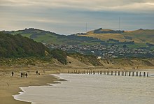
Saint Clair, New Zealand
| St Clair | |
|---|---|

St Clair Beach
|
|
| Basic information | |
| Local authority | Dunedin |
| Date established | 1850s |
| Population | 4,179 (2006) |
| Surrounds | |
| North | Forbury, Kew |
| Northeast | South Dunedin |
| East | St Kilda |
| South | Pacific Ocean |
| West | St Clair Park |
| Northwest | Corstorphine |
St Clair is a leafy residential suburb of Dunedin, New Zealand. It is located on the Pacific Ocean coast five kilometres from the city centre on the southwesternmost part of the coastal plain which makes up the southern part of the urban area, and also climbs the slopes of Forbury Hill immediately to the west of this plain. St Clair's 2001 population was 4,179.
St Clair's main geographical features are St Clair Beach, the western end of the long beach (Ocean Beach) which stretches along the city's southern shore, and the promontory of Forbury Hill which rises 159 metres (522 ft) above the plain. The summit of the hill lies within the grounds of St Clair Golf Course, in the west of the suburb.
Forbury Hill's flanks include a large cliff face one kilometre inland from the beach and a rocky headland which juts into the Pacific Ocean. The small outcrop of White Island lies to the immediate south of St Clair beach. The inland cliff, which runs parallel with and to the west of Forbury Road, was the site of a quarry in the early days of the city. The city's largest retirement village and its only meetinghouse for the LDS Church both lie in the shadow of this cliff.
The beach and the dunes are often the victims of erosion if weather patterns see series of storms hit the city from the south. Such erosion between 2002 and 2007 saw emergency measures taken to add sand to the dunes in 2007 and 2008. Further erosion in 2013–2015 encroached on the dunes to the extent that a public footpath inland from the top of the dunes was permanently closed. The erosion is a long-term ongoing concern, as evidenced by attempts at beach protecting begun in 1904 which saw the addition of sturdy wooden piles and sandbreaks to the beach. The last surviving sets of wooden posts from these efforts are a landmark of St Clair Beach, often seen as being the dividing line between St Clair and Middle Beaches. Heavy storms during the winter of 2015 left these posts in a poor condition, and it is likely they will not survive many more years.
Another beach, Second Beach, lies to the west of St Clair Beach, separated from it by a rocky outcrop on which lies St Clair Hot Salt Water Pool. Second Beach is rocky rather than sandy, and is flanked by cliffs that form the head of Forbury Hill, some of which include hexagonal basalt columns, one of three such outcrops in Dunedin (the others being at Blackhead, further to the west, and at the Organ Pipes formation on Mount Cargill. This natural amphitheatre is now largely wild but easily reached by a footpath leading from behind the Salt Water Pool. A distinctive feature of Second Beach is a natural blowhole, located at its southwestern end, at the far end of the footpath. Second Beach was the site of quarrying operations in the early days of Dunedin, but only the overgrown remnants of concrete walls are today left of this.
...
Wikipedia
