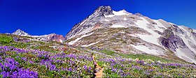
Sahale Mountain
| Sahale Mountain | |
|---|---|

Sahale Arm below Sahale Peak
|
|
| Highest point | |
| Elevation | 8,680+ft (2,650+m) NGVD 29 |
| Prominence | 80 ft (20 m) |
| Coordinates | 48°29′28″N 121°02′20″W / 48.4912382°N 121.0390017°WCoordinates: 48°29′28″N 121°02′20″W / 48.4912382°N 121.0390017°W |
| Geography | |
| Location | Chelan / Skagit counties, Washington, U.S. |
| Parent range | North Cascades |
| Topo map | USGS Cascade Pass |
| Climbing | |
| First ascent | August 1897 by John Charlton and Albert H. Sylvester |
| Easiest route | Climb, class 3–4, from Cascade Pass |
Sahale Mountain is a jagged, glaciated mountain, in North Cascades National Park, in northern Washington state. The summit of Sahale Mountain is referred to as Sahale Peak. It is just 0.3 miles (0.48 km) south of its higher neighbor, Boston Peak, and the saddle between the two is only 80 feet (24 m) lower than Sahale's summit. Quien Sabe Glacier is to the west of the ridge between the two peaks while Davenport Glacier is in a cirque east of this ridge and above Horseshoe Basin. Sahale Glacier is south of the summit and east of Sahale Arm, a ridge that extends southwest from Sahale to Cascade Pass.
Sahale Peak is noted for its panoramic views and is popular among mountaineers. The least technical route follows the Sahale Arm from the Cascade Pass Trail to the Sahale Glacier. From the glacier there is a class 3–4 climb to the summit. Another option is to traverse from the Sahale Arm onto the Quien Sabe Glacier and climb the glacier to the rock ridge north of the peak. The climb up this ridge is also class 3–4 but crosses some loose rock and is more exposed.Cascade Pass and the Sahale Arm can be reached from Marblemount to the west or from the east, it is accessible via a trail, from Stehekin, up the Stehekin River valley.
...
Wikipedia
