Sa Pa
|
Sa Pa Thị trấn Sa Pa |
|
|---|---|
| Township | |
| Sa Pa Township | |

Sa Pa town
|
|
| Location of in Vietnam | |
| Coordinates: 22°21′N 103°52′E / 22.350°N 103.867°E | |
| Country | Vietnam |
| Province | Lào Cai |
| District | Sa Pa |
| Area | |
| • Total | 24.02 km2 (9.27 sq mi) |
| Population (2009) | |
| • Total | 8,975 |
| • Density | 373.6/km2 (968/sq mi) |
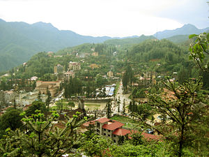
Sa Pa (![]() listen), or Sapa, is a frontier township and capital of Sa Pa District in Lào Cai Province in north-west Vietnam. It is one of the main market towns in the area, where several ethnic minority groups such as Hmong, Dao (Yao), Giáy, Pho Lu, and Tay live.
listen), or Sapa, is a frontier township and capital of Sa Pa District in Lào Cai Province in north-west Vietnam. It is one of the main market towns in the area, where several ethnic minority groups such as Hmong, Dao (Yao), Giáy, Pho Lu, and Tay live.
Sa Pa is a frontier township and capital of Sa Pa District in Lào Cai Province in north-west Vietnam. It was first inhabited by people we know nothing about. They left in the entire valley hundreds of petroglyphs, mostly composed of lines, which experts think date from the 15th century and represent local cadastres. Then came the highland minorities of the Hmong and Yao. The township is one of the main market ones in the area, where several ethnic minority groups such as Hmong, Dao (Yao), Giáy, Pho Lu, and Tay live. groups, as well as by smaller numbers of Tày and Giay. These are the four main minority groups still present in Sa Pa district today. The Kinh (lowland Vietnamese) never originally colonised this highest of Việt Nam’s valleys, which lies in the shadow of Phan-Xi-Pǎng (Fansipan, 3143 m), the highest peak in the country.
It was only when the French debarked in highland Tonkin in the late 1880s that Sa Pa, name of the Hmong hamlet, with "S" is pronounced almost as hard as "Ch" in French, "Sh" in English, "S" in standard Vietnamese, so Chapa as the French called it, began to appear on the national map. Near to the now Sa Pa townlet is "Sa Pả commune", which shows the origin in Hmong language of the location name.
...
Wikipedia

