SH20 Waterview Connection

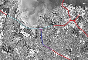
While generally considered a "tunnel project", the Waterview Connection also includes other large motorway works. The connection consists of the purple (above ground) and dark blue (bored tunnels) sections. The section of SH16 with extra lanes added is shown in light blue.
|
|
| Location | Auckland, New Zealand |
|---|---|
| Proposer | NZ Transport Agency |
| Website | http://www.nzta.govt.nz/projects/waterviewconnection |
| Status | Opened 2 July 2017 |
| Type | Road & tunnel |
| Cost estimate | $1.7 billion |
| Stakeholders | Government of New Zealand, NZ Transport Agency, Auckland Council, Campaign for Better Transport, Cycle Action Auckland, Friends of Oakley Creek, North West Community Association, various further community groups and submitters |
The Waterview Connection is a motorway section through west/central Auckland, New Zealand. It connects State Highway 20 in the south at Mt Roskill to State Highway 16 in the west at Point Chevalier, and is a part of the Western Ring Route.
The Waterview Connection is 4.5 km long, of which 2.5 km are in the form of twin tunnels. The Waterview Tunnel supersedes the Lyttelton Road Tunnel as New Zealand's longest road tunnels. By 2026, the link is expected to carry 83,000 vehicles a day. There are three lanes of traffic in each tunnel.
The project has had an extensive planning history, with the earliest consultation having occurred in 2000, though the proposal for a route roughly in the area dates from much earlier.
Several routes were considered, all being variations of either a connection to SH16 along the Rosebank Peninsula (e.g. AR1, AR3) or at the Great North Road interchange at Waterview (e.g. AW1, AW4). It was generally assumed that below-ground construction would be required where AR3 passed through Avondale Heights, to a maximum depth of 41 m. On the basis of technical and environmental assessments, the AR3 and AW4 route options were dismissed.
Transit New Zealand selected the Waterview connection as its preferred route, with the support of the Auckland City Council and Waitakere City Council, over the Rosebank option, which was the preferred route of the Auckland Regional Council. The previous AW1 and AW4 routes favoured a New North Road interchange with ramps facing south, and full connections at the Waterview interchange. The preferred route was announced with a Great North Road interchange replacing New North Road and no southbound access at Waterview. This proved unpopular with local residents, and it was considered unlikely a bored tunnel could accommodate an interchange because of its depth.
On 7 February 2008, bored tunnels were announced as Transit's preferred option. The NZ Transport Agency's preferred option was a pair of two-lane tunnels costing $1.89 billion, rather than a pair of three-lane tunnels costing $2.14 billion. NZTA's traffic modelling indicated that two-lane tunnels would reach capacity within 10 years of operation.Map of Tunnel Route
...
Wikipedia
