Sơn La Province
|
Sơn La Province Tỉnh Sơn La |
|
|---|---|
| Province | |
 |
|
 Location of Sơn La within Vietnam |
|
| Coordinates: 21°10′N 104°0′E / 21.167°N 104.000°ECoordinates: 21°10′N 104°0′E / 21.167°N 104.000°E | |
| Country |
|
| Region | Northwest |
| Capital | Sơn La |
| Area | |
| • Total | 14,055 km2 (5,427 sq mi) |
| Population (2004) | |
| • Total | 972,800 |
| • Density | 69/km2 (180/sq mi) |
| Demographics | |
| • Ethnicities | Vietnamese, Tai, H'Mông, Mường, Dao |
| Time zone | ICT (UTC+7) |
| Area codes | 212 |
| ISO 3166 code | VN-05 |
| Website | www |
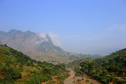
Sơn La (![]() listen) is a province in the Northwest region of Vietnam. It borders Laos to the south. The population includes Black and White Tai.
listen) is a province in the Northwest region of Vietnam. It borders Laos to the south. The population includes Black and White Tai.
Sơn La Dam, the largest hydroelectric power station in Southeast Asia. is located in this province.
Sơn La is subdivided into 12 district-level sub-divisions:
They are further subdivided into 9 commune-level towns (or townlets), 188 communes, and 7 wards.
The province's name derives from Sino-Vietnamese .
...
Wikipedia
