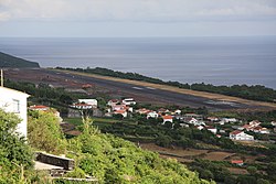
São Jorge Airport
|
São Jorge Airport Aerodrómo de São Jorge |
|||||||||||
|---|---|---|---|---|---|---|---|---|---|---|---|
 |
|||||||||||
| Summary | |||||||||||
| Airport type | Public | ||||||||||
| Owner | Azores | ||||||||||
| Operator | SATA Aerodromos Lda. | ||||||||||
| Serves | Velas, Azores | ||||||||||
| Location | Santo Amaro | ||||||||||
| Opened | 22 September 1989 | ||||||||||
| Elevation AMSL | 335 ft / 102 m | ||||||||||
| Coordinates | 38°39′55″N 28°10′29″W / 38.66528°N 28.17472°WCoordinates: 38°39′55″N 28°10′29″W / 38.66528°N 28.17472°W | ||||||||||
| Map | |||||||||||
| Location of the aerodrome of São Jorge, relative to the archipelago of the Azores | |||||||||||
| Runways | |||||||||||
|
|||||||||||
|
Source: Portuguese AIP GCM Google Maps SkyVector
|
|||||||||||
São Jorge Airport (Portuguese: Aérodromo de São Jorge) (IATA: SJZ, ICAO: LPSJ) is the only airport of the island of São Jorge, situated in the civil parish of Santo Amaro, municipality of Velas in the Azores.
The airport is on the edge of Fajã do Queimado, along the southern coast, situated 6 km (3.7 mi) southeast of Velas and 28 km (17 mi) northwest of Calheta.
...
Wikipedia

