Rutshuru Territory
| Rutshuru Territory | |
|---|---|

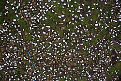
Partial view of the town of Kitchanga
|
|
| Coordinates: 1°11′14″S 29°26′46″E / 1.187265°S 29.446004°ECoordinates: 1°11′14″S 29°26′46″E / 1.187265°S 29.446004°E | |
| Country | Democratic Republic of Congo |
| Province | North Kivu |
Rutshuru Territory is a territory in the North Kivu province of the eastern Democratic Republic of the Congo (DRC), with headquarters is the town of Rutshuru.
The territory is mountainous, including a large portion of the Virunga National Park, famous for its mountain gorillas. The people of the territory are extremely poor. Since 1992 they have suffered from ongoing violent conflict between different rebel groups and government troops. At its peak in November 2008 an estimated 250,000 people were made homeless. The violence has caused health issues, including the need for treatment after rape, which is common. Children have stayed away from those schools that are open for fear of being kidnapped by armed groups and made to fight.
The territory lies in the Albertine Rift between Lakes Edward and Kivu. The Rutshuru River runs north through the territory, emptying into Lake Edward It is bounded on the north by Luberi Territory and Lake Edward. The eastern boundary is the international border with Uganda, and further south with Rwanda. To the south is the Nyiragongo Territory, beyond which is the provincial capital of Goma. To the east is Masisi Territory and Walikale Territory. The strategically important town of Kanyabayonga is just north of the territory on the road from Goma to Butembo. The territory includes a large part of the Virunga Mountains and Virunga National Park, which includes Mount Mikeno, an extinct volcano that rises to 14,557 feet (4,437 m). The territory includes Bwito Chiefdom in the mountainous western section and Bwisha Chiefdom in the lower-lying eastern section.
...
Wikipedia

