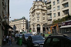
Rue du Bac

Rue du Bac
|
|
| Length | 1,150 m (3,770 ft) |
|---|---|
| Width | 20 m (66 ft) (average) between quais Anatole France and Voltaire and the boulevard Saint-Germain. 18 m between the Boulevard Saint-Germain and the rue de Sèvres |
| Arrondissement | 7th |
| Quarter | Saint-Thomas d'Aquin |
| From | quai Voltaire, Paris and quai Anatole France |
| To | rue de Sèvres, Paris |
| Construction | |
| Completion | Opened between 1600 à 1610 |
Rue du Bac is a street in Paris situated in the 7th arrondissement. The street, which is 1150 m long, begins at the junction of the quais Voltaire and Anatole-France and ends at the rue de Sèvres. The street used to be in the fashionable Faubourg Saint-Germain.
Rue du Bac is also the name of a station on line 12 of the Paris Métro, although its entrance is actually located on the boulevard Raspail at the point where it is joined by the rue du Bac.
Rue du Bac owes its name to a ferry (bac) established toward 1550 on what is now the quai Voltaire, to transport stone blocks for the construction of the Palais des Tuileries. It crossed the Seine at the site of today's Pont Royal, bridge constructed under the reign of Louis XIV to replace the pont rouge built in 1632 by the financier Barbier.
Originally, the street was named grand chemin du Bac, then ruelle du Bac and grande rue du Bac.
(French) This article was drawn mainly from the .
Coordinates: 48°51′23″N 2°19′35″E / 48.85639°N 2.32639°E
...
Wikipedia

