Row River
| Row River | |
|
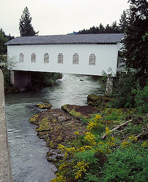
Dorena Bridge over the Row River
|
|
| Name origin: A dispute or row between two brothers-in-law who lived near the stream | |
| Country | United States |
|---|---|
| State | Oregon |
| County | Lane |
| Source | Cascade Range |
| - location | Confluence of Brice Creek and Layng Creek, Lane County, Oregon |
| - elevation | 1,121 ft (342 m) |
| - coordinates | 43°42′13″N 122°46′13″W / 43.70361°N 122.77028°W |
| Mouth | Coast Fork Willamette River |
| - location | near Cottage Grove, Lane County, Oregon |
| - elevation | 617 ft (188 m) |
| - coordinates | 43°49′14″N 123°02′36″W / 43.82056°N 123.04333°WCoordinates: 43°49′14″N 123°02′36″W / 43.82056°N 123.04333°W |
| Length | 20 mi (32 km) |
| Discharge | for near Cottage Grove, 5.5 miles (8.9 km) from mouth |
| - average | 728 cu ft/s (21 m3/s) |
| - max | 21,400 cu ft/s (606 m3/s) |
| - min | 0.20 cu ft/s (0 m3/s) |
The Row River is a river, approximately 20 miles (32 km) long, in Lane County, Oregon, United States. It rises in the Cascade Range and flows into the Coast Fork Willamette River near Cottage Grove. The stream was originally known as the "East Fork Coast Fork", but was later renamed after a dispute () between neighbors and brothers-in-law George Clark and Joseph Southwell over "trespassing" livestock. Clark was killed as a result of the row. The name rhymes with "cow" rather than with "slow". A post office named Row River operated from 1911 to 1914 a little north of the present site of Dorena at 43°44′24″N 122°52′49″W / 43.740123°N 122.880347°W.
The Row River, about 20 miles (32 km) long, drains a portion of the Umpqua National Forest on the west face of the central Oregon Cascades between Cottage Grove and Oakridge. Its headwaters are near the unincorporated community of Disston, where Layng Creek and Brice Creek join at 43°42′12″N 122°46′15″W / 43.70331°N 122.77093°W. The river flows predominately westward.
...
Wikipedia


