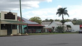
Rosedale, Queensland
|
Rosedale Queensland |
|||||||||||||||
|---|---|---|---|---|---|---|---|---|---|---|---|---|---|---|---|

Rosedale, 2016
|
|||||||||||||||
| Coordinates | 24°37′0″S 151°55′0″E / 24.61667°S 151.91667°ECoordinates: 24°37′0″S 151°55′0″E / 24.61667°S 151.91667°E | ||||||||||||||
| Population | 448 (2011 census) | ||||||||||||||
| Postcode(s) | 4674 | ||||||||||||||
| Location | |||||||||||||||
| LGA(s) | |||||||||||||||
| State electorate(s) | |||||||||||||||
| Federal Division(s) | Flynn | ||||||||||||||
|
|||||||||||||||
Rosedale is a town and locality split between the Gladstone Region and the Bundaberg Region in central Queensland, Australia. At the 2011 census, Rosedale and the surrounding area had a population of 448.
The town is 423 kilometres (263 mi) north of the state capital Brisbane and 58 kilometres (36 mi) north west of the regional centre of Bundaberg. The town is on the North Coast railway line.
Most of the locality is in the Gladstone Region but a small southern part on the shores of Lake Monduran is in the Bundaberg Region. Despite the town itself being in the Gladstone Region local government area, Rosedale is closer to Bundaberg than Gladstone. There has been some interest in the Rosedale community regarding breaking away from the Gladstone Region.
The Rosedale and Tottenham war memorial commemorating the fallen in World War I and World War II is located in James Street, beside the Memorial Hall.
In 2004, a north-bound tilt train derailed injuring 120 passengers.
The town also has a P–12 school catering for students from Rosedale, Lowmead, Agnes Water, 1770, Winfield and Yandaran.
Facilities in the town include a pub, a tea house and a general store.
...
Wikipedia

