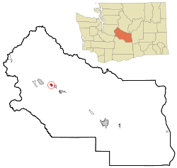
Ronald, Washington
| Ronald, Washington | |
|---|---|
| CDP | |
 Location of Ronald, Washington |
|
| Coordinates: 47°14′6″N 121°1′36″W / 47.23500°N 121.02667°WCoordinates: 47°14′6″N 121°1′36″W / 47.23500°N 121.02667°W | |
| Country | United States |
| State | Washington |
| County | Kittitas |
| Area | |
| • Total | 0.8 sq mi (2.1 km2) |
| • Land | 0.8 sq mi (2.1 km2) |
| • Water | 0.0 sq mi (0.0 km2) |
| Elevation | 2,349 ft (716 m) |
| Population (2000) | |
| • Total | 265 |
| • Density | 332.2/sq mi (128.3/km2) |
| Time zone | Pacific (PST) (UTC-8) |
| • Summer (DST) | PDT (UTC-7) |
| ZIP code | 98940 |
| Area code(s) | 509 |
| FIPS code | 53-59635 |
| GNIS feature ID | 1525199 |
Ronald is a census-designated place (CDP) in Kittitas County, Washington, United States. The population was 265 at the 2000 census.
Ronald was named for Alexander Ronald, a former coal mine superintendent in the area.
Ronald is located at 47°14′6″N 121°1′36″W / 47.23500°N 121.02667°W (47.235096, -121.026613).
According to the United States Census Bureau, the CDP has a total area of 0.8 square miles (2.1 km²), all of it land.
This region experiences warm (but not hot) and dry summers, with no average monthly temperatures above 71.6 °F. According to the Köppen Climate Classification system, Ronald has a warm-summer Mediterranean climate, abbreviated "Csb" on climate maps.
As of the census of 2000, there were 265 people, 103 households, and 66 families residing in the CDP. The population density was 332.2 people per square mile (127.9/km²). There were 186 housing units at an average density of 233.2/sq mi (89.8/km²). The racial makeup of the CDP was 96.23% White, 1.13% African American, 1.51% Native American, 0.38% Asian, 0.38% from other races, and 0.38% from two or more races. Hispanic or Latino of any race were 2.64% of the population.
...
Wikipedia
