Romblon, Romblon
| Romblon | |
|---|---|
| Municipality | |

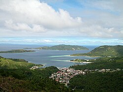
Romblon town and Romblon Bay
|
|
 Map of Romblon Province with Romblon Municipality highlighted |
|
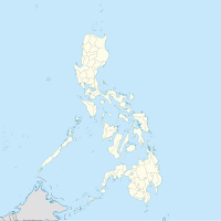
| Location within the Philippines | |
| Coordinates: 12°34′N 122°16′E / 12.567°N 122.267°ECoordinates: 12°34′N 122°16′E / 12.567°N 122.267°E | |
| Country | Philippines |
| Region | MIMAROPA (Region IV-B) |
| Province | Romblon |
| District | Lone district |
| Founded | 1571 (as encomienda) |
| 1631 (as pueblo) | |
| Barangays | 31 |
| Government | |
| • Type | Municipal |
| • Mayor | Mariano M. Mateo (NP) |
| • Vice Mayor | Mac-Mac Silverio (NP) |
| • Councilors | Wiwet Rugas Nene Lim Orly Magano Raymund Robis Pido Riano Melben Mesana Toing Morante Jun Mariño |
| Area | |
| • Total | 86.87 km2 (33.54 sq mi) |
| Highest elevation | 444 m (1,457 ft) |
| Population (2015) | |
| • Total | 38,758 |
| • Density | 450/km2 (1,200/sq mi) |
| Time zone | PST (UTC+8) |
| Zip Code | 5500 |
| IDD : area code | 42 |
| Income class | 3rd Class |
Romblon is a third-class municipality and capital of Romblon province, Philippines. In the 2015 census, it had a population of 38,758 inhabitants.Romblomanon or Ini is the native language of its residents.
Romblon Island, seat of the municipality of Romblon, is one of the three major islands of Romblon province. The islands were first visited by Spanish conquistador Martin de Goiti in late 1569, and were thereafter organized by the Spanish into encomiendas. The encomienda of Donblon (Romblon), established on April 24, 1571, was granted to Don Gonzalo Riquel. In the first census done by Spanish navigator Miguel de Loarca in 1582, Romblon Island was shown to have 240 residents engaged in wax gathering.
In 1631, during the term of Spanish Governor-General Juan Niño de Tabora, Romblon was established as a pueblo, making it one of the two oldest settlements in the province, the other being Banton located in the north of the province. It received its first Spanish missionaries in the 17th century. During the 17th and 18th centuries, it was often ravaged by Moros.
It was organized into a Comandancia (a province or district under military control) by the Spanish in 1853.
In 1901, the American occupation saw the establishment of a civilian government in the town. Ten new barrios were created while three existing barrios were also abolished. These include Aglomiom which was merged to Sablayan due to its small population, Embarcacion which was attached again to El Pueblo or Poblacion and the inland barrio of Cogon which was reorganized and split into five barrios of Tambac, Ilauran, Macalas, Lamao, and Agbaluto (referred collectively as TIMLA, from its initial letters) while barrio Alfonso XIII was renamed Calabogo.
The ten additional barrios were Bagacay, Agbudia, Agtongo, Embarcacion, Maria Cristina (renamed as Sawang) and the five new TIMLA barrios. These barrios aside from TIMLA were Agtongo which was created into a separate barrio in 1916 taken from Cajimos while in 1918 those engaged in maritime industry which were designated separately as distinct barrio known as Embarcacion was annexed again to barrio Poblacion or El Pueblo in 1939. Agbudia was the last barrio to be created taken from Guimpingan in 1939. Meanwhile, the two barrios Majabangbaybay and Sogod, located in Tablas island, were returned to Badajoz (now San Agustin), abolished as independent barrios and attached as sitios of barrio Guinpuc-an (Carmen) in 1901.
...
Wikipedia

