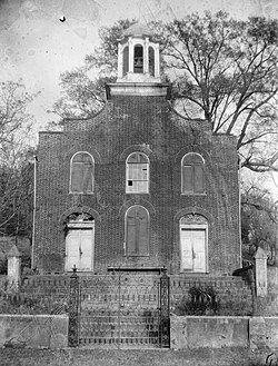
Rodney, Mississippi
|
Rodney Center Historic District
|
|

Former First Presbyterian Church
|
|
| Location | Jefferson County, Mississippi |
|---|---|
| Nearest city | St. Joseph, Louisiana/Lorman, Mississippi |
| Coordinates | 31°51′41″N 91°11′59″W / 31.86139°N 91.19972°WCoordinates: 31°51′41″N 91°11′59″W / 31.86139°N 91.19972°W |
| Area | 60 acres (24 ha) |
| Architectural style | Greek Revival, Gothic Revival, Federal |
| NRHP reference # | 80002255 |
| Added to NRHP | August 29, 1980 |
| Rodney, Mississippi | |
|---|---|
| Nickname(s): "Petite Gulf", "Little Gulf" | |
| Country | United States |
| State | Mississippi |
| County | Jefferson County |
| Founded | 1828 |
| Elevation | 82 ft (25 m) |
| Population (2010)U6 | |
| • Total | >0 |
| Time zone | EST (UTC-6) |
| GNIS feature ID | 676809 |
Rodney is a former city in Jefferson County in southwest Mississippi, approximately 32 miles (51 km) northeast of Natchez. Rodney was founded in 1828, and in the 19th century, it was only three votes away from becoming the capital of the Mississippi Territory. Its population declined to nearly zero after the Mississippi River changed course. The Rodney Center Historic District is listed on the National Register of Historic Places.
Today a small number of inhabitants remain but the area is considered a ghost town and reliable data is hard to find as the town is not listed as a separate entity by the census bureau.
Rodney was originally settled by the French in January 1763 and named Petit Gouffre, meaning "Little Chasm". As a result of the French and Indian War, the area was taken by Great Britain. Spain would later control this area after taking West Florida from the British in 1781. Spain would hold the site until selling it to Thomas Calvit in 1798. The city was later renamed Rodney in 1828 in honor of Judge Thomas Rodney.
The Old Rodney Presbyterian Church was dedicated in 1832. It is located at the middle section of the town, across the Rodney – Red Lick – Lorman Road from Alston Grocery Store. Formerly at the south edge of the town was Sacred Heart Catholic Church, built in 1869. On the southeast corner of Rodney lies Alston's Grocery, operated by the Alston family since 1915.
Alston's Grocery Store, actually a country general store, closed many years ago but the building still stands. In the northeast corner of the town is a small park where regular band concerts were held by the Jefferson County Band. On the northwest corner are remains of a wooden drugstore. West of Alston's Grocery is the one surviving structure on Batchelor Street. Located at the southwest corner is a two-story brick structure. At the western end of Batchelor St. is Mt. Zion No. 1 Baptist Church, a white frame structure combining several styles of architecture which was constructed in 1850. The Presbyterian Church has a solid shot above the middle window which appears to have been fired by a 12 lb. Napoleon. It hit the facade of the church when a group of officers from the USS Rattler decided to attend services one Sunday and a unit of Confederate cavalry from Grand Gulf began the process of arresting them all as prisoners of war. Shooting started and the Rattler returned fire striking the Church (Note: The shell one sees lodged in the facade of the church today is not the original round. That particular missile has been lost to history. The current round, cemented in place for safety, was placed there during a restoration in the 1990s). The minister, a known Union sympathizer, left town shortly thereafter.
...
Wikipedia


