Rodenkirchen
| Rodenkirchen | ||
|---|---|---|
| 2nd District of Cologne | ||

Hauptstraße with Cologne Rodenkirchen Bridge in the background
|
||
|
||
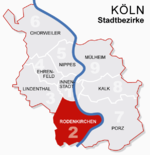
 Location of Rodenkirchen shown in red |
||
| Country | Germany | |
| Federal state | North Rhine-Westphalia | |
| City | Cologne | |
| Area | ||
| • Total | 54.6 km2 (21.1 sq mi) | |
| Population (December 2008) | ||
| • Total | 100,935 | |
| • Density | 1,850/km2 (4,800/sq mi) | |
Rodenkirchen (German: Köln-Rodenkirchen) is a southern city district of Cologne (Köln) in Germany. It has about 100,000 inhabitants and covers an area of 54.56 square kilometres (21.06 mile²). The borough includes the quarters Bayenthal, Godorf, Hahnwald, Immendorf, Marienburg, Meschenich, Raderberg, Raderthal, Rodenkirchen, Sürth, Rondorf, Weiß and Zollstock.
The 1000-year-old quarter Rodenkirchen, situated close to the Rhine, today represents the center of the borough. It has more than 16,000 inhabitants.
Rodenkirchen is made up of 13 Stadtteile (city parts):
St. Maternus was built according to the plans of Vinvenz Statz from 1863 to 1867 at the former place of the Carthusian.
St. Maternus was built as a gothic church with only a few ornamentations. It has a tympanum with St. Maternus standing between two angels in front of a panorama of Cologne. Inside the church there is a madonna from Alt St. Maternus (English: Old St. Maternus), the former St. Maternus from 1470.
The ship named "Alte Liebe" (English: Old Love) is a landmark well-known beyond the town of Rodenkirchen. Originally constructed in 1947, it burned down and was restored three times. Today it is used as a restaurant and for events such as weddings.
Gustav-Heinemann-Ufer connects Rodenkirchen with the Cologne Ring, Bundesautobahn 555 connects Rodenkirchen with the Cologne Beltway.
Rodenkirchen is the name of a Cologne Stadtbahn station, connected to the city centres of Cologne and Bonn by line 16.
Rodenkirchen is "twinned" with the following cities:
Coordinates: 50°53′29″N 6°59′28″E / 50.89139°N 6.99111°E
...
Wikipedia

