Rockledge, Pennsylvania
| Borough of Rockledge | |
| Borough | |
|
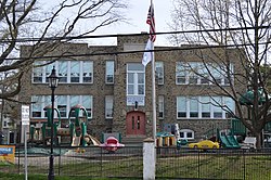
Municipal building on Huntingdon Pike
|
|
| Country | United States |
|---|---|
| State | Pennsylvania |
| County | Montgomery |
| Elevation | 223 ft (68.0 m) |
| Coordinates | 40°04′56″N 75°05′23″W / 40.08222°N 75.08972°WCoordinates: 40°04′56″N 75°05′23″W / 40.08222°N 75.08972°W |
| Area | 0.3 sq mi (0.8 km2) |
| - land | 0.3 sq mi (1 km2) |
| - water | 0.0 sq mi (0 km2), 0% |
| Population | 2,543 (2010) |
| Density | 7,428.9/sq mi (2,868.3/km2) |
| Government | Council-manager |
| Mayor | Harold Praediger |
| Timezone | EST (UTC-5) |
| - summer (DST) | EDT (UTC-4) |
| ZIP code | 19046 |
| Area code | 215 and 267 |
|
Location of Rockledge in Montgomery County
|
|
|
Location of Pennsylvania in the United States
|
|
| Website: http://www.rockledgeborough.org | |
Rockledge is a borough in Montgomery County, Pennsylvania, United States. The population was 2,543 at the 2010 census.
Rockledge is located at 40°4′56″N 75°5′23″W / 40.08222°N 75.08972°W (40.082310, -75.089600).
According to the United States Census Bureau, the borough has a total area of 0.3 square miles (0.78 km2), all of it land.
As of the 2010 census, the borough was 95.8% White, 0.4% Black or African American, 1.2% Asian, and 2.0% were two or more races. 2.0% of the population were of Hispanic or Latino ancestry [1].
As of the census of 2000, there were 2,577 people, 1,060 households, and 645 families residing in the borough. The population density was 7,428.9 people per square mile (2,842.8/km2). There were 1,091 housing units at an average density of 3,145.1 per square mile (1,203.5/km2). The racial makeup of the borough was 97.98% White, 0.04% African American, 0.04% Native American, 0.97% Asian, 0.31% from other races, and 0.66% from two or more races. Hispanic or Latino of any race were 0.58% of the population.
...
Wikipedia


