River Tillingham
| River Tillingham, East Sussex | |
|---|---|

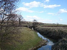
The river at Beckley
|
|
| Country | England |
| Basin features | |
| Main source | Staplecross, Ewhurst, East Sussex 300 feet (90 m) |
| River mouth |
River Brede, Rye sea level |
The River Tillingham flows through the English county of East Sussex. It meets the River Brede and the eastern River Rother near the town of Rye. A navigable sluice controlled the entrance to the river between 1786 and 1928, when it was replaced by a vertical lifting gate which was not navigable. The river provided water power to operate the bellows of an iron works at Beckley Furnace, used to make cannons for the Royal Navy between 1578 and 1770, when it became uneconomic, and a water mill which replaced it, until that burnt down in 1909. The lower reaches supported a thriving shipbuilding industry from the early nineteenth century onwards, and although on a smaller scale, was still doing so in 2000.
The ancient course of the Tillingham was rather different from its present one, as the river discharged into a broad area defined by islands, tidal creeks and salt marshes during the Roman period, rather than the estuary of the River Rother. The thirteenth century was a time of turmoil, as from the 1240s there was a period of 60 years when weather conditions were extreme. Old Winchelsea, which was built on a huge mound of shingle to the east of the mouth, was threatened with flooding, and ultimately succumbed. Following extensive flooding, including the washing away of the church on 1271, a new town was established further to the west on a hill near Iham, just to the south of the Tillingham, in 1280. In 1287, a great storm deposited large amounts of shingle and mud on the port of Romney, and blocked up the mouth of the River Rother, which carved out a new route to the sea near Rye, where it joined the Tillingham and the River Brede.
A major project of river engineering was carried out in 1596, when the course of the Rother was diverted around the northern edge of Rye to join the Tillingham. The scheme was expensive, and untimately was not a success, as the Rother reverted to its previous course to the east on Rye in 1610. Another attempt at engineering the mouths of the three rivers began in 1723, when an Act of Parliament was obtained to authorise the construction of a new channel from the Brede near Winchelsea to the sea. After great expense and 63 years work, the channel, called the New Harbour, was opened in July 1787, and the old outlet to the sea was closed. A wet autumn caused extensive flooding of the hinterland, and in November 1787, after just four months, the New Harbour was abandoned, and the old channel from Rye to the sea was reopened. A navigable sluice was constructed across the Tillingham in 1786, just above Strand Quay. Its function was to prevent salt water flowing up the river, and to improve the scouring of the channel below it. At the same time, wharfs were constructed at Ferry Bridge, Leasam Farm, Marshall’s Farm and Marley Farm, the final one around 2 miles (3.2 km) above the sluice. It is not entirely clear how the lock was used, since maps from 1872 carry a note that the sluice was the highest point to which tides flowed, but maps from 1898 and 1907 state that tides flowed for a further 3 miles (4.8 km) beyond the sluice when the lock gates were opened. Navigation on most of the Tillingham ended in 1928, when the sluice was replaced by a vertical lifting gate.
...
Wikipedia
