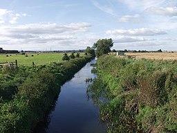
River Perry, Shropshire
| River Perry | |
|
The river crossing Baggy Moor
|
|
| Country | England |
|---|---|
| Counties | Shropshire |
| Source | |
| - location | Springs near Gobowen |
| - elevation | 260 m (853 ft) |
| Mouth | |
| - location | River Severn, near Shrewsbury |
| - elevation | 60 m (197 ft) |
| - coordinates | 52°44′40″N 2°49′51″W / 52.7445°N 2.8308°WCoordinates: 52°44′40″N 2°49′51″W / 52.7445°N 2.8308°W |
| Length | 39 km (24 mi) |
| Discharge | for Yeaton |
| - average | 1.6 m3/s (57 cu ft/s) |
The River Perry is a river in Shropshire, England. It rises near Oswestry and flows south to meet the River Severn above Shrewsbury. The channel has been heavily engineered, both to enable water mills to be powered by it, and to improve the drainage of the surrounding land. The middle section crosses Baggy Moor, where major improvements were made in 1777 to drain the moor, and a section of the river bed was lowered in the 1980s, to continue the process. The river was the scene of a major pollution incident in 1985, when pig slurry discharged into it, killing around 100,000 fish.
The river rises as a series of springs near Hengoed, to the west of Gobowen and to the north of Oswestry, close to the 500-foot (150 m) contour. It passes under the Shrewsbury to Ruabon railway line and the A5 road, to skirt around the northern edge of Gobowen. It is joined by several other streams, which also rise at springs to the west of Gobowen, some from as high as 850 feet (260 m) above sea level, and another which rises near New Marton, and flows south, passing under the Llangollen Canal.
Passing under the A495 road to the north of Whittington, it enters the parkland of Halston Hall, supplying a large ornamental lake. The hall is a red-brick country house, originally built in the 1690s, but altered for its owner John Mytton by Robert Mylne between 1766 and 1768. It is a grade I listed structure. The river briefly heads south to leave the park, and then turns to the east, where it is crossed by the Montgomery Canal. At this point it is below the 260-foot (80 m) contour. The Perry aqueduct, which carries the canal over the river, was the scene of a major breach in 1936, which led to the canal closing. It was not reopened until 1987.
Next it turns to the south, passing through Baggy Moor, where it is joined by a large number of drainage ditches. The railway line crosses it again, before it reaches Ruyton-XI-Towns, where there is a large loop around higher ground to the east. The river is crossed by Platt Mill Bridge, designed and built in 1791 by Edward Cureton. The river forms the border between civil parishes at this point, and so one half of the bridge is in Ruyton-XI-Towns, while the other is in Baschurch. The bridge has two arches, and is a grade II listed structure. A circular toll-house, built of red sandstone with a conical slate roof, was erected in the late eighteenth or early nineteenth century close to the bridge, and is now used as a house. Continuing to the south-west of Baschurch, Milford Bridge is another two-arched structure, which carries the Baschurch to Little Ness road over the river. It was designed by Thomas Stanton in 1831, and was built by Nathaniel Edwards. Stanton was the civil engineer Thomas Telford's deputy at the time, when Telford was the County Surveyor of Bridges for Shropshire. The river passes along the south-western edge of Yeaton Peverey parkland, to reach Forton Heath, where there is a bridge with a single elliptical arch, built in the early nineteenth century, which carries the Mytton to Forton road. Below the bridge, the river joins the River Severn. The junction is not far from Shrewsbury, but the course of the Severn is much longer, as it flows around several large meanders to reach the town.
...
Wikipedia

