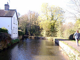
River Frome, Dorset
|
River Frome |
|
|
River Frome near Dorchester
|
|
| Country | United Kingdom |
|---|---|
| County | Dorset |
| Source | |
| - location | Evershot, Dorset |
| - elevation | 175 m (574 ft) |
| - coordinates | 50°50′15″N 2°36′02″W / 50.83750°N 2.60056°W |
| Mouth | |
| - location | Poole, Dorset |
| - coordinates | 50°41′45″N 1°59′19″W / 50.69583°N 1.98861°WCoordinates: 50°41′45″N 1°59′19″W / 50.69583°N 1.98861°W |
| Discharge | for East Stoke |
| - average | 6.38 m3/s (225 cu ft/s) |
| - max | 27.9 m3/s (985 cu ft/s) 30 December 1993 |
| - min | 1.05 m3/s (37 cu ft/s) 26 August 1976 |
| Discharge elsewhere (average) | |
| - Dorchester | 3.09 m3/s (109 cu ft/s) |
The River Frome /ˈfruːm/ is a river in Dorset in the south of England. At 30 miles (48 km) long it is the major chalkstream in southwest England. It is navigable upstream from Poole Harbour as far as the town of Wareham.
The river rises in the Dorset Downs at Evershot, passes through Maiden Newton, Dorchester, West Stafford and Woodsford. At Wareham it and the River Piddle, also known as the River Trent, flow into Poole Harbour via the Wareham Channel. The catchment area is 181 square miles (454 km²) map, approximately one sixth of the county.
East of Dorchester the river runs over sands, clays and gravels which overlie the chalk; as the valley gradient is gentle the Frome has deposited much sediment here and thus created a broad flood plain. Historically this contained marshes and gave the name to the Durotriges, water dwellers, the Celtic tribe of Dorset. The river forms a wide, shallow ria at its estuary, Poole Harbour.
Prior to the end of the last ice age the Purbeck Hills were continuous with the Isle of Wight and the Frome would have continued east through what is now Poole Harbour and Poole Bay, into The Solent, collecting the Stour, Beaulieu, Test and Itchen, before flowing into the Channel east of what is now the Isle of Wight.
...
Wikipedia


