River Doe Lea
| Doe Lea | |
|---|---|

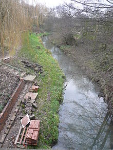
The river near Doe Lea
|
|
| Country | England |
| Basin features | |
| Main source |
Pilsley 705 feet (215 m) |
| River mouth |
River Rother 163 feet (50 m) 53°17′22″N 1°20′14″W / 53.2894°N 1.3373°WCoordinates: 53°17′22″N 1°20′14″W / 53.2894°N 1.3373°W |
| Physical characteristics | |
| Length | 11 miles (18 km) |
The River Doe Lea is a river which flows near Glapwell and Doe Lea in Derbyshire, England. The river eventually joins the River Rother near Renishaw. The river contained 1000 times the safe level of dioxins in 1991, according to a statement made by Dennis Skinner, (MP) in the House of Commons in 1992. The river flows through the former site of Coalite Chemicals near Bolsover, where coke, tar and industrial chemicals were manufactured until the plant closed in 2004.
The stream section is designated an SSSI for its geological interest.
The river flows in a generally south to north direction through a region where the underlying geology is predominantly Carboniferous coal measures. To the east of its catchment there is a band of Permian Magnesian Limestone, which forms an escarpment. Magnesian Limestone is so called because it contains quantities of the mineral dolomite, which is rich in magnesium. The river and its tributary streams drain an area of about 26.2 square miles (68 km2). During its 11-mile (18 km) course, it descends from an altitude of 705 feet (215 m) to around 163 feet (50 m) at the point where it joins the River Rother.
The stream section of the river is a designated geological Site of Special Scientific Interest; according to the SSSI citation, it "shows an internationally significant section through the Upper Coal Measures of the Carboniferous" and is "one of Britain's most important geological sites."
...
Wikipedia
