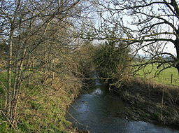
River Boyd
| Boyd | |
| River | |
| Name origin: British Celtic virtue, favour, blessing or benefit | |
| Country | England |
|---|---|
| Region | West Country |
| District | South Gloucestershire |
| Tributaries | |
| - right | Feltham Brook |
| City | Bristol |
| Source | Springs Farm |
| - location | Dodington, South Gloucestershire, England |
| - elevation | 427 ft (130 m) |
| - coordinates | 51°30′04″N 2°22′02″W / 51.5011°N 2.3673°W |
| Mouth | Bristol Avon |
| - location | Bitton, South Gloucestershire, England |
| - elevation | 49 ft (15 m) |
| - coordinates | 51°25′01″N 2°27′39″W / 51.4170°N 2.4608°WCoordinates: 51°25′01″N 2°27′39″W / 51.4170°N 2.4608°W |
| Length | 7 mi (11 km), south |
| Discharge | |
| - average | 19.8 cu ft/s (1 m3/s) |
| - max | 979 cu ft/s (28 m3/s) |
| - min | 0.35 cu ft/s (0 m3/s) |
| River system | Bristol Avon |
|
Diagrammatic map of the River Boyd and tributaries in South Gloucestershire
|
|
The River Boyd is a river of some 7 miles (11 km) in length which rises near Dodington in South Gloucestershire, England. It is a tributary of the Bristol Avon, running in a southerly direction and joining near Bitton. The flow rate at Bitton is an average 19.8 cubic feet per second (0.56 m3/s). It was immortalised in the 1613 poem by John Dennys of Pucklechurch The Secrets of Angling, the earliest English poetical tract on fishing:
And thou sweet Boyd that with thy watry sway
Dost wash the cliffes of Deington and of Weeke
And through their Rockes with crooked winding way
Thy mother Avon runnest soft to seeke
In whose fayre streames the speckled Trout doth play
The Roche the Dace the Gudgin and the Bleeke
Teach me the skill with slender Line and Hooke
To take each Fish of River Pond and Brooke.
In common with other rivers of the area, watermills were used for various industrial undertakings, most notably the Wick Golden Valley Ochre Works. The former works site is now a local nature reserve and the river and valley form part of a Site of Nature Conservation Interest.
The Boyd rises from springs near Sands Farm, just south of Dodington Chase. Several small tributaries join on the right from springs issuing from a ridge of high land to the north. The river then passes underneath the M4 motorway, being joined by further streams from the direction of Codrington. Just before Doynton tributaries emanating from Dyrham join on the left bank. The Feltham Brook joins on the right bank, from the direction of Pucklechurch, near Doynton House and the river then passes under Cleeve Bridge and enters the steep Golden Valley, where a nature reserve has been established.
Passing under Boyd Bridge in Wick, the river turns in a southerly direction, running parallel to the Monarch's Way long distance footpath. Emerging from Golden Valley just north of Bitton, the Boyd skirts the village and then meanders across river meadows before joining the Bristol Avon adjacent to the point where the Bristol and Bath Railway Path crosses the Avon.
...
Wikipedia


