Risaralda Department
|
Risaralda Department Departamento del Risaralda |
|||
|---|---|---|---|
| Department | |||
|
|||
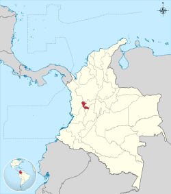
 Risaralda shown in red |
|||
 Topography of the department |
|||
| Coordinates: 4°49′N 75°42′W / 4.817°N 75.700°WCoordinates: 4°49′N 75°42′W / 4.817°N 75.700°W | |||
| Country |
|
||
| Region | Andes Region | ||
| Established | July 1, 1966 | ||
| Capital | Pereira | ||
| Government | |||
| • Governor | Sigifredo Salazar Osorio (2016-2019) | ||
| Area | |||
| • Total | 4,140 km2 (1,600 sq mi) | ||
| Area rank | 29th | ||
| Population (2013) | |||
| • Total | 941,283 | ||
| • Rank | 18th | ||
| • Density | 230/km2 (590/sq mi) | ||
| Time zone | UTC-05 | ||
| ISO 3166 code | CO-RIS | ||
| Municipalities | 14 | ||
| Website | www.risaralda.gov.co | ||
Risaralda is a department of Colombia. It is located in the western central region of the country and part of the Paisa Region. Its capital is Pereira.
It was divided from the department of Caldas in 1966. Risaralda is very well known for the high quality of its coffee, and a booming industry: clothes, food, trading of goods and services.
The territory is very mountainous and has many kinds of climates in a very small area. Its proximity to harbours such as Buenaventura on the Pacific Ocean and to the biggest cities in Colombia – Bogotá, Cali, Medellín – makes it a fast-growing economic centre.
Risaralda department with an area of 365,300 ha, is located in the central sector of the central Andean region west of the country between two major poles of economic development (department of Antioquia in northern and southern Cauca Valley, extending between the central and western Cordillera), which slopes down toward the Río Cauca, also borders the departments of Caldas in the north-east, east Tolima, Quindio Chocó south and west.
The department's drainage system consists of two major basins, the Cauca River and the San Juan River. Physiographical formations are covered by the volcanic massifs of the central and western mountain ranges, flat and narrow valleys formed by the natural river basins of the Otún River, the Cauca River, Risaralda River, and La Vieja River.
Its main stages are: Nevado de Santa Isabel (Pereira), Cerro de Tatamá (Sanctuary), Cerro de Caramanta (Mistrató), Alto de las Palomas (Pueblo Rico), Alto de Pelahuevos (APIA), Blade la Serna (Mistrató), San Juan Blade (APIA), Blade of the Content (APIA), Blade Tribune (Pereira), Alto del Nudo and Morro Azul (Pereira), Alto de la Campana (APIA) and the Crystalline High (Belen de Umbria.)
...
Wikipedia


