Rift Valley province
|
Rift Valley Province Mkoa wa Bonde la Ufa |
|
|---|---|
| Former Province | |

Rift Valley
|
|
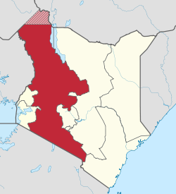
 Location in Kenya. |
|
| Coordinates: 0°30′N 36°0′E / 0.500°N 36.000°ECoordinates: 0°30′N 36°0′E / 0.500°N 36.000°E | |
| Country |
|
| No. of Counties: | 14 |
| Capital | Nakuru |
| Area | |
| • Total | 182,505.1 km2 (70,465.6 sq mi) |
| Population (2009) | |
| • Total | 10,006,805 |
| • Density | 55/km2 (140/sq mi) |
| Time zone | EAT (UTC+3) |
Rift Valley Province (Swahili: Mkoa wa Bonde la Ufa) of Kenya, bordering Uganda, was one of Kenya's 8 provinces, before the Kenyan general election, 2013. Rift Valley Province was the largest and one of the most economically important provinces in Kenya. It was dominated by the Kenya Rift Valley which passes through it and gives the province its name. According to the 2009 Census, the former province covered an area of 182,505.1 square kilometres (45,098,000 acres; 70,465.6 sq mi) and would have had a population of 10,006,805, making it the largest and most populous province in the country. The bulk of the provincial population is a strip between former Nairobi and Nyanza Province. The capital was the town of Nakuru.
As of March 2013 after the Kenyan general election, 2013, the Province was divided into counties and Rift Valley Province was no more.
The Great Rift Valley runs south through Kenya from Lake Turkana in the north and has several unique geographical features, including the Elgeyo escarpment which is a popular tourist attraction.
Apart from the Rift Valley itself, the area has other important geographic features such as: the extinct volcanoes Mount Longonot and Mount Suswa and Lake Baringo, Lake Bogoria, Lake Magadi, Lake Nakuru, Lake Naivasha, the Suguta Valley, and Lake Turkana.
...
Wikipedia
