Rice Creek (Mississippi River)
| Rice Creek | |
|---|---|

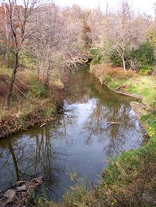
Rice Creek in Fridley
|
|
| Country | United States |
| Basin features | |
| Main source | Clear Lake, Forest Lake, Minnesota 890 ft (270 m) |
| River mouth |
Mississippi River, Fridley, Minnesota 806 ft (246 m) |
| Basin size | 201 sq mi (520 km2) |
| Physical characteristics | |
| Length | 28 mi (45 km) |
Rice Creek is a tributary of the Mississippi River in the northern suburbs of the Minneapolis–St. Paul metropolitan area of Minnesota in the United States. It is approximately 28 miles (45 km) long and drains a watershed of 201 square miles (520 km2).
Rice Creek has its source at Clear Lake in the city of Forest Lake in Washington County and flows generally southwestwardly through Anoka and Ramsey Counties, through the cities of Columbus, Lino Lakes, Circle Pines, Shoreview, Arden Hills, Mounds View, New Brighton and Fridley. It joins the Mississippi River at Manomin County Park in Fridley, about 1.5 miles (2.4 km) north of the I-694 Bridge. The creek drops about 84 feet (26 m) along its course, from its source elevation of 890 feet (271 m) to its mouth at 806 feet (246 m), with most of the drop (64 ft/20 m) occurring in the 8 miles (13 km) upstream of its mouth; a lowland floodplain adjoins the stream in this reach.
In Anoka County, Rice Creek passes through an extensive network of lakes known as the Lino Lakes Chain of Lakes, a portion of which is preserved in the Rice Creek Chain of Lakes Regional Park Reserve, a regional park maintained by the government of Anoka County. In New Brighton, the creek passes through Long Lake, which is bordered by Long Lake Regional Park, maintained by Ramsey County. In Fridley, the lower course of creek is roughly paralleled by the Rice Creek West Regional Trail, a biking and hiking trail.
...
Wikipedia
