Rhondda Fach
| Rhondda | |
|---|---|
| Valley region | |
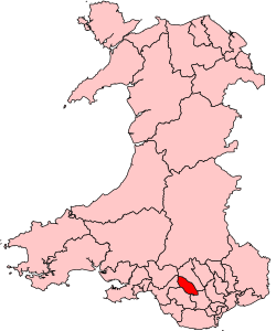
 Map showing location of the Rhondda Valley within Wales |
|
| Sovereign state | United Kingdom |
| Constituent country | Wales |
| County borough | Rhondda Cynon Taf |
| Parliamentary constituency | Rhondda |
| Area | |
| • Total | 38.59 sq mi (99.94 km2) |
| Highest elevation | 1,935 ft (590 m) |
| Population (2001) | |
| • Total | 59,602 |
| • Density | 1,500/sq mi (600/km2) |
| Time zone | Greenwich Mean Time (UTC+0) |
| • Summer (DST) | British Summer Time (UTC+1) |
| Postal code | CF postcode area |
| Area code(s) | 01443 |
Coordinates: 51°36′57″N 3°25′03″W / 51.615938°N 3.417521°W
Rhondda /ˈrɒnðə/, or the Rhondda Valley (Welsh: Cwm Rhondda [kʊm ˈr̥ɔnða]), is a former coal mining valley in Wales, formerly a local government district, consisting of 16 communities built around the River Rhondda. The area is, in fact, made up of two valleys: those of the larger Rhondda Fawr valley (mawr large) and the smaller Rhondda Fach valley (bach small). The singular term 'Rhondda Valley' and the plural 'Rhondda Valleys' are both commonly used. In 2001 the Rhondda constituency of the National Assembly for Wales had a population of 72,443; while the National Office of Statistics described the Rhondda urban area as having a population of 59,602. Rhondda is part of Rhondda Cynon Taf County Borough and is part of the South Wales Valleys.
...
Wikipedia
