Rhinns of Islay

Orsay Lighthouse
|
|
|
Argyll and Bute
|
|
| Location | Orsay Isle Islay Inner Hebrides Scotland United Kingdom |
|---|---|
| Coordinates | 55°40′23″N 6°30′47″W / 55.673122°N 6.513112°W |
| Year first constructed | 1825 |
| Automated | 1998 |
| Construction | masonry tower |
| Tower shape | cylindrical tower with balcony and lantern |
| Markings / pattern | white tower, black lantern, ochre trim |
| Height | 29 metres (95 ft) |
| Focal height | 46 metres (151 ft) |
| Light source | solar power |
| Intensity | 600.000 candela |
| Range | 24 nautical miles (44 km; 28 mi) |
| Characteristic | Fl W 5s. |
| Admiralty number | A4256 |
| NGA number | 4232 |
| ARLHS number | SCO-184 |
| Managing agent | Northern Lighthouse Board |
| Heritage |
Site of Special Scientific Interest |
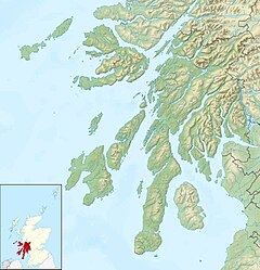
The Rinns of Islay (Scottish Gaelic: Na Roinn Ìleach; alternative English spelling Rhinns of Islay) is an area on the west of the island of Islay in the Inner Hebrides of Scotland.
It is a peninsula that is attached to the main body of the island by a narrow isthmus towards its northern end. The main population centres are Port Charlotte and Portnahaven, based on the A847 that runs along its eastern coast.
It is designated a Special Protection Area due to its importance for a number of breeding and wintering birds, particularly Greenland white-fronted goose and chough. The significance of the area owes much to its wide variety of habitats including bog, moorland, dune grassland, maritime grassland, marsh and extensively-farmed agricultural land.
The Rinns of Islay lighthouse is located on the island of Orsay.
The Rhinns complex, a deformed igneous complex that is considered to form the basement to the Colonsay Group of metasedimentary rocks takes its name from the Rhinns of Islay.
Coordinates: 55°44′22″N 6°26′19″W / 55.73954°N 6.43872°W
...
Wikipedia

