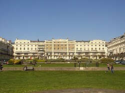
Regency Square, Brighton
| Regency Square | |
|---|---|

General view of the square from the south
|
|
| Location | Regency Square, Brighton, Brighton and Hove, East Sussex, United Kingdom |
| Coordinates | 50°49′21″N 0°09′01″W / 50.8226°N 0.1504°WCoordinates: 50°49′21″N 0°09′01″W / 50.8226°N 0.1504°W |
| Built | 1818–1828 |
| Built for | Joshua Hanson |
| Architect | Amon Wilds, Amon Henry Wilds (attr.) |
| Architectural style(s) | Regency/Classical |
|
Listed Building – Grade II*
|
|
| Official name: 2–4 Regency Square; 5–20 Regency Square; 26–37 Regency Square; 51–56 Regency Square; 57–59 Regency Square; 60–66 Regency Square; 131 King's Road |
|
| Designated | 13 October 1952 |
| Reference no. | 481126; 481127; 481129; 481135; 481136; 481137; 482002 |
|
Listed Building – Grade II
|
|
| Official name: 22–25 Regency Square; 38–46 Regency Square; 46a Regency Square; 46b Regency Square; 47–49 Regency Square |
|
| Designated | 20 August 1971 (38–46); 26 August 1999 (others) |
| Reference no. | 481128; 481130; 481131; 481132; 481133 |
Regency Square is a large early 19th-century residential development on the seafront in Brighton, part of the British city of Brighton and Hove. Conceived by speculative developer Joshua Hanson as Brighton underwent its rapid transformation from fishing village to fashionable resort, the three-sided "set piece" of around 70 houses and associated structures was designed and built over a ten-year period by Brighton's most important Regency-era architects: the partnership of Charles Busby, Amon Wilds and his son Amon Henry Wilds. The site was originally Belle Vue Field—used at various times as a military camp (mentioned in Pride and Prejudice), a showground and the location of a windmill.
The square was a prestigious, high-class development, attracting the social elite. The square gradually lost its prestige status after the First World War as hotels started to move in. The square's central garden, originally private, has been council-owned since 1884 and is publicly accessible, and an underground car park was built beneath it in 1969.
Most of the buildings in and around the square have been designated Listed buildings: six blocks of houses are each listed at Grade II*, the second-highest designation, while five other residential buildings, a war memorial, a nearby inn and a set of bollards outside it have each been given the lower Grade II status. The house at the southwest corner is now numbered as part of King's Road but was built as part of Regency Square, and is also Grade II*-listed.
Regency Square was built on one of the fields surrounding the fishing village of Brighthelmstone, the predecessor of modern-day Brighton. The field was named Belle Vue Field—probably in connection with the long vanished Belle Vue House, and lay to the west of the village. The field ran down to the seafront, and was a popular site for travelling shows, fairs, military parades and other gatherings. The field contained a windmill known as West Mill. A windmill was owned by Matthew Bourne in 1744, but was not marked on Ogilby's 1762 map. A windmill is shown on Lambert's View of Brighthelmstone which is dated 1765. The windmill stood in the field until 28 March 1797, when 86 oxen dragged it 2 miles (3.2 km) uphill on a sled to the nearby village of Preston. It was re-erected there and renamed Preston Mill. After several more renamings, it was demolished in 1881. Its machinery was cannibalised by the owners of nearby Waterhall Mill. A watercolour painting, now displayed at Preston Manor, shows crowds of people watching the mill's removal to Preston.
...
Wikipedia

