Red Rock, Oklahoma
|
Red Rock Íno Súje |
|
|---|---|
| Town | |
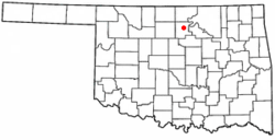
 Location of Red Rock, Oklahoma |
|
| Coordinates: 36°27′36″N 97°10′45″W / 36.46000°N 97.17917°WCoordinates: 36°27′36″N 97°10′45″W / 36.46000°N 97.17917°W | |
| Country | United States |
| State | Oklahoma |
| County | Noble |
| Area | |
| • Total | 0.2 sq mi (0.6 km2) |
| • Land | 0.2 sq mi (0.6 km2) |
| • Water | 0.0 sq mi (0.0 km2) |
| Elevation | 925 ft (282 m) |
| Population (2000) | |
| • Total | 294 |
| • Density | 1,199.6/sq mi (463.2/km2) |
| Time zone | Central (CST) (UTC-6) |
| • Summer (DST) | CDT (UTC-5) |
| ZIP code | 74651 |
| Area code(s) | 580 |
| FIPS code | 40-62650 |
| GNIS feature ID | 1097121 |
Red Rock (Otoe: Íno Súje pronounced [ĩꜜno suꜜdʒɛ], meaning "Rock Red") is a town in northern Noble County, Oklahoma, United States. The population was 283 at the 2010 census, a decline from 293 at the 2000 census. The headquarters of the Otoe-Missouria Tribe of Indians is located in Red Rock.
In 1886, the Atchison, Topeka and Santa Fe Railroad built a line through what would become Noble County. The land around the railroad crossing of Red Rock Creek still belonged to the Otoe-Missouri reservation, but a trading post operated there. A post office named "Magnolia" opened at the trading post in March 1890. The name was changed to Red Rock in June 1892.
On April 26, 1991 a large F4 tornado touched down within one mile of the town. The tornado was rated because of the minimal damage that occurred. The tornado held the record for the highest recorded wind speed of 257–268 mph until the Bridge Creek, Oklahoma tornado of May 3, 1999 in the 1999 Oklahoma tornado outbreak which had a wind gust of 318 mph.
Red Rock is located at 36°27′36″N 97°10′45″W / 36.46000°N 97.17917°W (36.459934, -97.179226). According to the United States Census Bureau, the town has a total area of 0.2 square miles (0.52 km2), all of it land.
As of the census of 2000, there were 293 people, 97 households, and 71 families residing in the town. The population density was 1,199.6 people per square mile (471.4/km²). There were 107 housing units at an average density of 438.1 per square mile (172.1/km²). The racial makeup of the town was 20.48% White, 73.72% Native American, and 5.80% from two or more races. Hispanic or Latino of any race were 1.02% of the population.
...
Wikipedia
