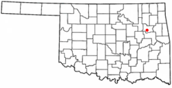
Red Bird, Oklahoma
| Redbird, Oklahoma | |
|---|---|
| Town | |
 Location of Redbird, Oklahoma |
|
| Coordinates: 35°53′19″N 95°35′18″W / 35.88861°N 95.58833°WCoordinates: 35°53′19″N 95°35′18″W / 35.88861°N 95.58833°W | |
| Country | United States |
| State | Oklahoma |
| County | Wagoner |
| Area | |
| • Total | 0.8 sq mi (2.1 km2) |
| • Land | 0.8 sq mi (2.1 km2) |
| • Water | 0.0 sq mi (0.0 km2) |
| Population (2010) | |
| • Total | 137 |
| • Density | 185.0/sq mi (71.4/km2) |
| Time zone | Central (CST) (UTC-6) |
| • Summer (DST) | CDT (UTC-5) |
| ZIP code | 74458 |
| Area code(s) | 539/918 |
| FIPS code | 40-62200 |
Redbird is a town in Wagoner County, Oklahoma, United States. The population was 137 at the 2010 census, a 10.5 percent decline from 153 at the 2000 census. Founded at the turn of the 20th century, it was one of more than fifty all-black towns in Oklahoma Territory and Indian Territory. It is one of thirteen surviving black communities in Oklahoma.
Redbird originated with the settlement by the family of E. L. Barber, who founded the First Baptist Church in 1889. Other families soon moved into the area. By 1902, Red Bird had obtained a post office. More than 600 people showed up at the official opening of Red Bird on August 10, 1907.
Redbird is located at 35°53′19″N 95°35′18″W / 35.88861°N 95.58833°W (35.888676, -95.588211).
According to the United States Census Bureau, the town has a total area of 0.8 square miles (2.1 km2), all of it land.
As of the census of 2000, there were 153 people, 64 households, and 33 families residing in the town. The population density was 185.0 people per square mile (71.2/km²). There were 76 housing units at an average density of 91.9 per square mile (35.4/km²). The racial makeup of the town was 87.58% African American, 5.88% Native American, 4.58% White, 0.65% from other races, and 1.31% from two or more races. Hispanic or Latino of any race were 1.96% of the population.
...
Wikipedia
