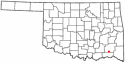
Rattan, Oklahoma
| Rattan, Oklahoma | |
|---|---|
| Town | |
 Location of Rattan, Oklahoma |
|
| Coordinates: 34°12′8″N 95°24′39″W / 34.20222°N 95.41083°WCoordinates: 34°12′8″N 95°24′39″W / 34.20222°N 95.41083°W | |
| Country | United States |
| State | Oklahoma |
| County | Pushmataha |
| Area | |
| • Total | 4.0 sq mi (10.3 km2) |
| • Land | 4.0 sq mi (10.3 km2) |
| • Water | 0.0 sq mi (0.0 km2) |
| Elevation | 466 ft (142 m) |
| Population (2000) | |
| • Total | 241 |
| • Density | 60.6/sq mi (23.4/km2) |
| Time zone | Central (CST) (UTC-6) |
| • Summer (DST) | CDT (UTC-5) |
| ZIP code | 74562 |
| Area code(s) | 580 |
| FIPS code | 40-61950 |
| GNIS feature ID | 1097052 |
Rattan is a town in Pushmataha County, Oklahoma, United States. The population was 241 at the 2000 census.
Rattan is located at 34°12′8″N 95°24′39″W / 34.20222°N 95.41083°W (34.202167, –95.410914). According to the United States Census Bureau, the town has a total area of 4.0 square miles (10 km2), all land.
Established in approximately 1910, Rattan was named for Rattan, Texas, from which a number of its early white settlers came.
Rattan, Texas—located in Delta County, thirty miles south of Paris, Texas—was named for local postal officer Clarence V. Rattan in 1893. Following Oklahoma's statehood in 1907 a number of Delta County families relocated to the new Pushmataha County, among them Akins, Akards, and Helms. The Delta County family (or families) apparently establishing itself in Rattan has not been identified.
Originally overshadowed by the nearby white settlement of Belzoni, Oklahoma, Rattan did not become economically successful enough to merit its own United States Post Office until December 12, 1910. Belzoni’s success as a farming hub sapped Rattan of much of its potential vitality, and it was not until the former's decline that Rattan emerged as the population center of southeastern area of the county.
Prior to establishment of its post office with the name “Rattan”, the area was called Sulphur Springs, Indian Territory. Sulphur Springs, located 3/4 mile south-southeast of the highway intersection of OK 3 and OK 93 in present-day Rattan, was county seat of Cedar County, Choctaw Nation. It was established by the Choctaws’ Doaksville Constitution of 1860 and, in the manner of most Choctaw county seats, served a part-time role as legal and political center. It was never a sizeable permanent settlement and boasted almost no mercantile or retail stores.
...
Wikipedia
