Rastkogel
| Rastkogel | |
|---|---|
 |
|
| Highest point | |
| Elevation | 2,762 m (AA) (9,062 ft) |
| Isolation | 8.2 kilometres (5.1 mi) |
| Coordinates | 47°12′16″N 11°45′04″E / 47.20444°N 11.75111°ECoordinates: 47°12′16″N 11°45′04″E / 47.20444°N 11.75111°E |
| Geography | |
| Parent range | Tux Alps |
| Geology | |
| Mountain type | Rocky mountain |
| Climbing | |
| Easiest route | Three-hour hike from the Rastkogel Hut |
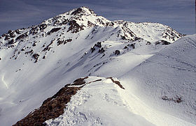
The Rastkogel is a 2,762 metre high, pyramidal, mountain on the main crest of the Tux Alps in the Austrian federal state of Tyrol.
The Rastkogel lies five kilometres north-northeast as the crow flies of Vorderlanersbach (municipality of Tux) in the Tuxertal, the westernmost side valley of the Zillertal. Its neighbouring peaks are: to the west, separated by the Nurpensjoch saddle (2,525 m), the Halslspitze at 2,574 metres, and beyond that over the Wattentaler Lizum, the Hirzer (2,725 m). To the north lies the Roßkopf (2,576 m) and - jutting far out into the Inn valley - the Gilfert (2,506 m) and, to the east, separated by the Hoarbergjoch (2,590 m), the Pangert at 2,550 metres.
Due to its prominent location in the south of the Tuxertal, the Rastkogel is an oft-frequented mountain. At its summit the crest divides like a cross into the three aforementioned directions, although its rock faces are mainly oriented in a north-south direction. To the south the massif drops relatively steeply into the Tuxertal.
An ascent of the Rastkogel as an Alpine mountain hike along the normal route, which is the easiest one, takes about 3 hours, approaching from the north along the southeast ridge (Südostgrat) from the Rastkogel Hut (2,117 m). Another route runs from the Weidener Hut (1,799 m) to the northwest over the Haslspitze and the west ridge (Westgrat) taking a good four hours to gain the summit.
On the southwest flank of the Rastkogels there is a skiing area that is reached from Vorderlanersbach on a ski lift.
...
Wikipedia

