Railroad, Pennsylvania
| Railroad | |
|---|---|
| Borough | |
 |
|
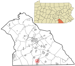
 Location in York County and the state of Pennsylvania. |
|
| Coordinates: 39°45′24″N 76°41′58″W / 39.75667°N 76.69944°WCoordinates: 39°45′24″N 76°41′58″W / 39.75667°N 76.69944°W | |
| Country | United States |
| State | Pennsylvania |
| County | York |
| Settled | 1792 |
| Incorporated | 1871 |
| Government | |
| • Type | Borough Council |
| Area | |
| • Total | 0.6 sq mi (2 km2) |
| Elevation | 804 ft (245 m) |
| Population (2010) | |
| • Total | 278 |
| • Density | 460/sq mi (180/km2) |
| Time zone | Eastern (EST) (UTC-5) |
| • Summer (DST) | EDT (UTC-4) |
| Zip code | 17355 |
| Area code(s) | 717 |
Railroad is a borough in York County, Pennsylvania, United States. The population was 278 at the 2010 census.
The borough owes its existence, and its name, to what became the Northern Central Railway, which was built connecting Baltimore, Maryland, and Harrisburg, Pennsylvania. The Railroad Borough Historic District was listed on the National Register of Historic Places in 1984.
Laura Randall described Railroad as a "tiny town of three hundred people near the Maryland border... home to the Jackson House B&B, a popular crab shack, and not much else."
Railroad is located at 39°45′24″N 76°41′58″W / 39.75667°N 76.69944°W (39.756761, -76.699396).
According to the United States Census Bureau, the borough has a total area of 0.6 square miles (1.6 km2), all of it land.
At the 2000 census, there were 300 people, 112 households and 79 families residing in the borough. The population density was 478.7 per square mile (183.9/km²). There were 116 housing units at an average density of 185.1 per square mile (71.1/km²). The racial makeup of the borough was 96.33% White, 1.67% African American and 2.00% Native American. Hispanic or Latino of any race were 0.67% of the population.
...
Wikipedia
