Raikoke
| Native name: Райкоке 雷公計島 |
|
|---|---|

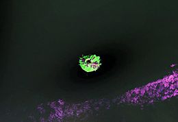
NASA Landsat view of Raikoke Island
|
|
 |
|
| Geography | |
| Location | Sea of Okhotsk |
| Coordinates | 48°17′30″N 153°14′30″E / 48.291667°N 153.241667°E |
| Archipelago | Kuril Islands |
| Area | 4.6 km2 (1.8 sq mi) |
| Highest elevation | 551 m (1,808 ft) |
| Highest point | Pik Raikoke |
| Administration | |
|
Russia
|
|
| Demographics | |
| Population | 0 |
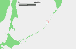
Raikoke (Russian: Райкоке, Japanese: 雷公計島), also spelled Raykoke, is an uninhabited volcanic island near the centre of the Kuril Islands chain in the Sea of Okhotsk in the northwest Pacific Ocean, 16 kilometres (9.9 mi) across Golovnin Strait from Matua. Its name is derived from the Ainu language, from “hellmouth”.
Raikoke is roughly circular, with a length of 2.5 kilometres (1.6 mi) with a width of 2.0 kilometres (1.2 mi), and an area of 4.6 square kilometres (1.8 sq mi). The island is a stratovolcano which rises above a submarine terrace with a depth of 130 metres to a maximum height of 551 metres (1,808 ft) above sea level. The steep-walled crater is 700 metres wide and 200 meters deep, and lava flows extend along the eastern half of the island. The volcano erupted explosively in 1778, destroying the upper third of the island. The volcano remains active, erupting strongly again in 1924.
Raikoke is one of five major Steller sea lion rookeries on the Kuril Islands and in the spring and summer it is home to one of the largest northern fulmar aggregations on the Kurils; crested and parakeet auklet, pigeon guillemot, and black-legged kittiwake also nest on the island. Captain Henry James Snow reported that in 1883 some 15,000 northern fur seals inhabited the island. However, by the 1890s only "a few scores" were recorded captured there, almost certainly due to overexploitation by fur hunters. Currently no fur seals reproduce on Raikoke.
...
Wikipedia
