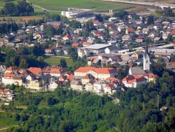
Radovljica
| Radovljica | |
|---|---|
| Town | |

Old town
|
|
| Location in Slovenia | |
| Coordinates: 46°20′33.06″N 14°10′19.48″E / 46.3425167°N 14.1720778°ECoordinates: 46°20′33.06″N 14°10′19.48″E / 46.3425167°N 14.1720778°E | |
| Country |
|
| Traditional region | Upper Carniola |
| Statistical region | Upper Carniola |
| Municipality | Radovljica |
| Area | |
| • Total | 4.9 km2 (1.9 sq mi) |
| Elevation | 491.2 m (1,611.5 ft) |
| Population (2012) | |
| • Total | 5,922 |
Radovljica (pronounced [ɾaˈdoːu̯ljitsa]; German: Radmannsdorf) is a town in the Upper Carniola region of northern Slovenia. It is the administrative seat of the Municipality of Radovljica.
The town is located on the southern slope of the Karawanks mountain range, about 6 km (3.7 mi) of Lake Bled at the confluence of the Sava Dolinka and the Sava Bohinjka, both headwaters of the Sava River. It lies at the southern end of the Radovljica Plain (Slovene: Radovljiška ravnina, also known as Dežela).
Radovljica station is a stop on the Tarvisio–Ljubljana Railway line.
The settlement around a church built at the behest of the Patriarchs of Aquileia in the March of Carniola was first mentioned in a 1296 deed, it received market rights from Duke Henry of Carinthia in 1333. In the 14th century it was held by the Carinthian Counts of Ortenburg, was inherited by the Counts of Celje in 1418, and, upon the death of Count Ulrich II of Celje in 1456, fell to the Habsburg Emperor Frederick III.
...
Wikipedia

