RAF Mousehold Heath
| RAF Mousehold Heath |
|||||||
|---|---|---|---|---|---|---|---|
| Near Norwich, Norfolk in England | |||||||

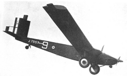
Beardmore Inflexible aircraft at the Norwich Air Display, Mousehold Aerodrome, May 1929
|
|||||||
|
Shown within Norfolk
|
|||||||
| Coordinates | 52°38′36″N 001°20′02″E / 52.64333°N 1.33389°ECoordinates: 52°38′36″N 001°20′02″E / 52.64333°N 1.33389°E | ||||||
| Type | Royal Air Force station | ||||||
| Site information | |||||||
| Owner | Air Ministry | ||||||
| Operator | Royal Air Force | ||||||
| Site history | |||||||
| Built | 1916 | ||||||
| In use | 1916-1933 | ||||||
| Airfield information | |||||||
| Elevation | 39 metres (128 ft) AMSL | ||||||
|
|||||||
The area of Norwich between the Salhouse and Plumstead roads (outside of the outer ring road) was originally the Cavalry Training Ground and then became the Royal Flying Corps Mousehold Heath aerodrome where Boulton Paul, among other manufacturers, passed over the aircraft they made for service. It was sometimes known as Norwich aerodrome by the Royal Flying Corps before it became Royal Air Force Station Mousehold Heath in April 1918.
After the First World War, Boulton and Paul continued to use the site. The Norwich & Norfolk Aero Club was formed at the airfield in 1927 which then became the first Norwich Airport in 1933. The airfield fell into disuse during the Second World War and has now mostly been redeveloped for housing.
The following squadrons and units were posted here at some point:
Several original buildings remain in industrial use, including hangars and other buildings on the Salhouse Industrial Estate. Part of the flying field survives as the playing field for the Open Academy, formerly Heartsease High School.
...
Wikipedia

