RAF Harrowbeer
|
RAF Harrowbeer |
|||||||||||||||||||
|---|---|---|---|---|---|---|---|---|---|---|---|---|---|---|---|---|---|---|---|

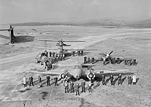
Aircraft and personnel required for a WWII Air/Sea rescue operation
|
|||||||||||||||||||
| Summary | |||||||||||||||||||
| Airport type | Military | ||||||||||||||||||
| Owner | Air Ministry | ||||||||||||||||||
| Operator | Royal Air Force | ||||||||||||||||||
| Location | Yelverton, Devon | ||||||||||||||||||
| Built | 1940 | ||||||||||||||||||
| In use | 1941-1950 | ||||||||||||||||||
| Coordinates | 50°29′27″N 004°05′36″W / 50.49083°N 4.09333°WCoordinates: 50°29′27″N 004°05′36″W / 50.49083°N 4.09333°W | ||||||||||||||||||
| Map | |||||||||||||||||||
| Location in Devon | |||||||||||||||||||
| Runways | |||||||||||||||||||
|
|||||||||||||||||||
|
Operating dates.
|
|||||||||||||||||||
RAF Harrowbeer is former Royal Air Force airfield situated next to Yelverton in the parish of Buckland Monachorum, Devon England
RAF Harrowbeer was located approximately 9 miles (14 km) NNE of the city of Plymouth and approximately 6 miles (9.7 km) south of , and also sits within the boundary of Dartmoor National Park. Roborough Rock is a tor-like igneous rock outcrop immediately south-west of the airfield on Roborough Down, next to the border with the A386. This location created problems for the airfield during the Second World War, as two runways were positioned in front of the rock.
Although sited near the village of Yelverton, it was called 'Harrowbeer' in order to distinguish it from the similar-sounding RNAS Yeovilton. The airfield was under the control of No. 10 Group RAF and was never assigned a station badge.
The former Ravenscroft School became the officers' mess.
The airfield opened in May 1941. It closed following the end of World War II.
A large number of units used the airfield at some point, such as:
...
Wikipedia

