RAF Castle Camps
|
RAF Castle Camps |
|||||||||||||||||||
|---|---|---|---|---|---|---|---|---|---|---|---|---|---|---|---|---|---|---|---|
| Summary | |||||||||||||||||||
| Airport type | Military | ||||||||||||||||||
| Operator | Royal Air Force | ||||||||||||||||||
| Location | Castle Camps, Cambridgeshire | ||||||||||||||||||
| Elevation AMSL | 420 ft / 128 m | ||||||||||||||||||
| Coordinates | 52°03′05″N 000°22′43″E / 52.05139°N 0.37861°ECoordinates: 52°03′05″N 000°22′43″E / 52.05139°N 0.37861°E | ||||||||||||||||||
| Map | |||||||||||||||||||
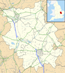
| Location in Cambridgeshire | |||||||||||||||||||
| Runways | |||||||||||||||||||
|
|||||||||||||||||||
RAF Castle Camps was listed as being in Cambridgeshire as it is close to its namesake Cambridgeshire village. It is very near the Suffolk border and the airfield straddled the Essex and Cambridgeshire county border. Construction of the station was started in September 1939. It opened as a satellite of RAF Debden in June 1940 and became a satellite of RAF North Weald in July 1943.
The airfield was used by numerous squadrons throughout the Second World War. In 1945, it was commanded by Battle of Britain ace Tim Vigors.It closed in January 1946.
The site has reverted to agricultural use. However the outlines of portions of the runways in the fields (when viewed on Google Earth), can still be seen and some of the perimeter roads are even now in use as farm tracks.
Some of the airfield buildings are still present and being used by local farms and industry.
...
Wikipedia

