Rümligen
| Rümligen | ||
|---|---|---|

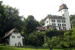
Rümligen Castle in Rümligen
|
||
|
||
| Coordinates: 46°50′N 7°30′E / 46.833°N 7.500°ECoordinates: 46°50′N 7°30′E / 46.833°N 7.500°E | ||
| Country | Switzerland | |
| Canton | Bern | |
| District | Bern-Mittelland | |
| Government | ||
| • Mayor | Martin Studer | |
| Area | ||
| • Total | 4.65 km2 (1.80 sq mi) | |
| Elevation | 606 m (1,988 ft) | |
| Population (Dec 2015) | ||
| • Total | 436 | |
| • Density | 94/km2 (240/sq mi) | |
| Postal code | 3128 | |
| SFOS number | 0881 | |
| Surrounded by | Gelterfingen, Kaufdorf, Kirchenthurnen, Riggisberg, Rüeggisberg | |
| Website |
www SFSO statistics |
|
Rümligen is a municipality in the Bern-Mittelland administrative district in the canton of Bern in Switzerland.
Rümligen is first mentioned in 1075 as Rumelingen.
The oldest trace of a settlement in the area is a cache of Early-Bronze Age axes. During the High Middle Ages the Freiherr von Rümligen owned a vast swathe of land between the Gürbe and Sense rivers. They donated some of their estates to found and support Rüeggisberg and Röthenbach Priories. In 1380 the Sommerau-Rümligen family inherited the land when Alisa von Rümligen married into the Sommerau family. In 1388 the Freiherren came under Bernese control, though they continued to own the estates for another century and a half. In 1515 the Sommerau-Rümligen lost the Herrschaft and by the 17th century a series of Bernese patrician families owned Rümligen. In 1709 Samuel Frisching, built the modern Rümligen Castle around the core of the medieval castle.
The village has always been part of the large parish of Thurnen.
The local farmers raised crops on the valley floor and pastured cattle in seasonal alpine camps. Today a large minority (43%) of the local jobs are still in agriculture. About two-thirds of the work force commutes to jobs in nearby cities. The municipal association runs a small school in the village.
Rümligen has an area of 4.65 km2 (1.80 sq mi). As of 2012, a total of 3.51 km2 (1.36 sq mi) or 75.5% is used for agricultural purposes, while 0.77 km2 (0.30 sq mi) or 16.6% is forested. The rest of the municipality is 0.35 km2 (0.14 sq mi) or 7.5% is settled (buildings or roads), 0.02 km2 (4.9 acres) or 0.4% is either rivers or lakes.
...
Wikipedia


