Rüderswil
| Rüderswil | ||
|---|---|---|

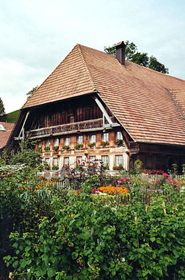
A farm house in the Zollbrück village in Rüderswil
|
||
|
||
| Coordinates: 46°59′N 7°43′E / 46.983°N 7.717°ECoordinates: 46°59′N 7°43′E / 46.983°N 7.717°E | ||
| Country | Switzerland | |
| Canton | Bern | |
| District | Emmental | |
| Government | ||
| • Mayor | Jürg Rothenbühler | |
| Area | ||
| • Total | 17.17 km2 (6.63 sq mi) | |
| Elevation | 655 m (2,149 ft) | |
| Population (Dec 2015) | ||
| • Total | 2,335 | |
| • Density | 140/km2 (350/sq mi) | |
| Postal code | 3437 | |
| SFOS number | 0905 | |
| Surrounded by | Hasle bei Burgdorf, Landiswil, Lauperswil, Lützelflüh, Trachselwald | |
| Website |
www SFSO statistics |
|
Rüderswil is a municipality in the administrative district of Emmental in the canton of Bern in Switzerland.
Rüderswil is first mentioned in 1139 as Rüderswile.
The oldest trace of settlements in the area are three high medieval castles in the hills above the modern town. The knight Adalbert von Rüderswil was mentioned in 1146 though little is known about the local noble family. By the Late Middle Ages the Teutonic Knights were a major landholder in the Rüderswil Herrschaft. The village church was first mentioned in 1275. The current church tower was built in the second half of the 14th century and the late-Gothic choir was built in the 15th century. In 1528, Bern adopted the new faith of the Protestant Reformation and Rüderswil converted along with the rest of the canton.
Rüderswil and the surrounding villages remained completely rural and agrarian until the 18th century when the canvas weaving cottage industry developed. A cheese factory opened in Rüderswil in 1853, followed by a spinning mill in Schachen in 1869. In 1881 a railroad station opened in Rüderswil. The station and the Emmental valley road in 1899 brought industry to the settlement on the right bank of the river, while the left bank remained dominated by agriculture. By 2005 about 42% of jobs in the municipality were still in agriculture, while only 25% are in industry. In 2009 an attempt to merge Rüderswil and Lauperswil was rejected by voters in Lauperswil.
Rüderswil has an area of 17.17 km2 (6.63 sq mi). As of 2012, a total of 11.7 km2 (4.5 sq mi) or 68.1% is used for agricultural purposes, while 4.07 km2 (1.57 sq mi) or 23.7% is forested. The rest of the municipality is 1.24 km2 (0.48 sq mi) or 7.2% is settled (buildings or roads), 0.17 km2 (0.066 sq mi) or 1.0% is either rivers or lakes.
...
Wikipedia


