Quendon
| Quendon | |
|---|---|
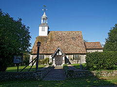
 Church of St Simon and St Jude, Quendon |
|
| Quendon shown within Essex | |
| Population | 450 (2001) |
| OS grid reference | TL514305 |
| Civil parish | |
| District | |
| Shire county | |
| Region | |
| Country | England |
| Sovereign state | United Kingdom |
| Post town | Saffron Walden |
| Postcode district | CB11 |
| Dialling code | 01799 |
| Police | Essex |
| Fire | Essex |
| Ambulance | East of England |
| EU Parliament | East of England |
| UK Parliament | |
Quendon is a linear village in the English county of Essex. Quendon is located on the B1383 (formerly the A11 trunk road) between Saffron Walden and Bishop's Stortford. The trunk road status was lost due to the opening of the parallel M11 motorway.
Quendon is part of Quendon and Rickling civil parish in the district of Uttlesford It is around 0.5 miles (1 km) from Rickling Green, the main village centre of Rickling. The first mention of a postal service in Quendon was in 1793 and the village had a Penny Post service from 1813. The village post office closed in February 2008.
The name of Quendon derives from the Old English "cwena" (queen, or woman) and "denu" (a valley), meaning the valley owned by a queen, or a woman; the queen referred to may be Ricula, wife of King Sledd of Essex, who gave her name to Rickling, the adjacent parish.The history of Quendon is closely associated with its close neighbour, Rickling village.
Quendon is mentioned in the Domesday Book, with 10 households populated by 3 villagers, 4 smallholders and 3 slaves.
Historically these two villages were separated by some distance, but it is thought that either due to the heavy loss of life during the 14th Century by the Black Death or a significant fire in the old wooden buildings of the day, caused much of the village to relocate its current position. The original Rickling village was closely sited near its own, now isolated parish church, approximately 1.5 km away.
Today, the villages nestle together and the boundary is almost unnoticeable Despite the close geographic tie between these two neighbours, the parishes were distinct until the late 20th century. The historic "Coffin Path" bridleway was used for the parish residents of Rickling to travel to its own church some distance over the fields. In 1520, it had become the property of Thomas Newman, who built the Hall, which was re-built in the 17th century by John Turner, Esq., who enclosed the park. It was sold during the last century to Henry Cranmer, Esq., from whom it descended to the late James Powell Cranmer, Esq.
...
Wikipedia

