Quemahoning Township, Somerset County, Pennsylvania
| Quemahoning Township, Somerset County, Pennsylvania |
|
|---|---|
| Township | |

|
|
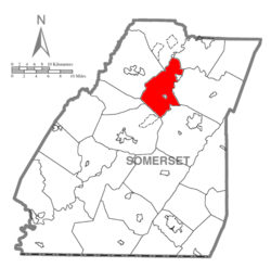
 Map of Somerset County, Pennsylvania Highlighting Quemahoning Township |
|
 Map of Somerset County, Pennsylvania |
|
| Country | United States |
| State | Pennsylvania |
| County | Somerset |
| Area | |
| • Total | 36.2 sq mi (94 km2) |
| • Land | 35.6 sq mi (92 km2) |
| • Water | 0.6 sq mi (2 km2) |
| Population (2000) | |
| • Total | 2,180 |
| • Density | 61.3/sq mi (23.7/km2) |
| Time zone | Eastern (EST) (UTC-5) |
| • Summer (DST) | EDT (UTC-4) |
Quemahoning Township is a township in Somerset County, Pennsylvania, United States. The population was 2,180 at the 2000 census. It is part of the Johnstown, Pennsylvania Metropolitan Statistical Area.
In 1775, Quemahoning Township was organized, by the Bedford County Court, out of part of Brothersvalley and Turkeyfoot townships. At that time, it included the northern portion of present-day Somerset County and part of what is now Cambria County. Its size was later reduced through the formation of new townships. When Somerset County was established in 1795 Quemahoning was one of the six original townships.
The Trostletown Bridge was added to the National Register of Historic Places in 1980.
According to the United States Census Bureau, the township has a total area of 36.2 square miles (93.7 km²), of which, 35.6 square miles (92.1 km²) of it is land and 0.6 square miles (1.6 km²) of it (1.74%) is water.
It is bordered on the west by Jenner Township, on the north by Conemaugh Township and Paint Township, on the east by Shade Township, and on the south by Stonycreek Township and Somerset Township. Quemahoning Township's eastern border is formed by the Stonycreek River and the north-western border by Quemahoning Creek, from which the township got its name. "Quemahoning" is an Indian word meaning "water issuing from a lick."
...
Wikipedia
