Quebradillas
| Quebradillas, Puerto Rico | ||
|---|---|---|
| Municipality | ||

View of the Guajataca Tunnel and coast line of Guajataca Beach
|
||
|
||
| Nickname(s): "La Guarida del Pirata", "La Ciudad Pirata", "La Ciudad del Cooperativismo", "El Rincón de Guajataca" | ||
| Anthem: "De lejos canto, porque anhela el corazón" | ||
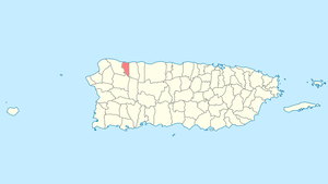
 Location of Quebradillas in Puerto Rico |
||
| Coordinates: 18°28′26″N 66°56′19″W / 18.47389°N 66.93861°WCoordinates: 18°28′26″N 66°56′19″W / 18.47389°N 66.93861°W | ||
| Country | United States | |
| Territory | Puerto Rico | |
| Founded | June 7, 1823 | |
| Government | ||
| • Mayor | Hon. Heriberto Velez Velez (PPD) | |
| • Senatorial dist. | 3 - Arecibo | |
| • Representative dist. | 15 | |
| Area | ||
| • Total | 27.7 sq mi (71.66 km2) | |
| • Land | 23.2 sq mi (60 km2) | |
| • Water | 4.5 sq mi (11.66 km2) | |
| Population (2010) | ||
| • Total | 25,919 | |
| • Density | 940/sq mi (360/km2) | |
| Demonym(s) | Quebradillanos | |
| Time zone | AST (UTC-4) | |
| Zip code | 00678 | |
Quebradillas (Spanish pronunciation: [keβɾaˈðiʎas], Smallbrooks) is a municipality of the island of Puerto Rico, located in the north-western shore bordering the Atlantic Ocean, north of San Sebastián; east of Isabela; and west of Camuy. Quebradillas is spread over seven wards and Quebradillas Pueblo (The downtown area and the administrative center of the city). It is part of the San Juan-Caguas-Guaynabo Metropolitan Statistical Area.
Quebradillas is called "La Guarida del Pirata" (The Pirate's Hideout). A well known beach in the area, Puerto Hermina, is home to an old structure known to have been a hiding place for pirates and their contraband.
The town was founded in 1823 by Felipe Ruiz. This town derives its name from the large amount of streams flowing through it. The name literally means "small streams".
Quebradillas is home to one of the 20 designated forest preserves in Puerto Rico, the Guajataca Forest. The forest serves as a great example of an unusual topography known as karst country. Karst is characterized by dissolved limestone formations such as sinkholes and haystack-shaped hills known as "mogotes". It is also home to the beautiful man-made reservoir, Guajataca Lake (2.5 mi or 4.0 km long), where you can fish for largemouth bass, peacock bass, tilapia and bluegill (in Spanish known as "chopa"). You can also go hiking or camping. The Boy Scouts of America maintain a campground on the lake known as Camp Guajataca. The name Guajataca comes from the name of a Taíno Indian chief who lived in this area. This Indian chief also gives his name to Guajataca Beach to the north where Río Guajataca flowing from Guajataca Lake meets the Atlantic Ocean. Guajataca Beach is popular with surfers and is known for its white sands and wild waters. This beach is ideal for sunning and collecting seashells.
...
Wikipedia

