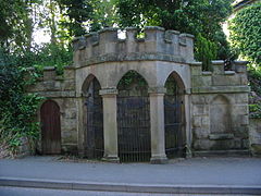
Quarndon, Derbyshire
| Quarndon | |
|---|---|
 Spring Well at the Chalybeate Wellhouse, Quarndon |
|
 Public footpaths and mixed pasture and wooded hills such as that pictured above in Quarndon reflect the parish's main 'green space' land use category. |
|
| Quarndon shown within Derbyshire | |
| Area | 4.49 km2 (1.73 sq mi) |
| Population | 933 (2011 census) |
| • Density | 208/km2 (540/sq mi) |
| OS grid reference | SK334410 |
| District | |
| Shire county | |
| Region | |
| Country | England |
| Sovereign state | United Kingdom |
| Post town | DERBY |
| Postcode district | DE22 |
| Police | Derbyshire |
| Fire | Derbyshire |
| Ambulance | East Midlands |
| EU Parliament | East Midlands |
Quarndon ![]() i/ˈkwɔːrn.dən/ is a linear village in the south of the Amber Valley District of Derbyshire, England. It is spread along four minor upland roads, approximately 1 mile north of the Derby suburb of Allestree, two of which lead towards the city.
i/ˈkwɔːrn.dən/ is a linear village in the south of the Amber Valley District of Derbyshire, England. It is spread along four minor upland roads, approximately 1 mile north of the Derby suburb of Allestree, two of which lead towards the city.
Many tourists throughout the 18th and early 19th centuries visited Quarndon's chalybeate springs within and next to its wellhouse. Many of these also sampled the waters of a geologically related spring in the grounds of its western neighbour, Kedleston Park and Hall, Kedleston – a village with a smaller population due to its few roads and single land-dominating estate which was once its manor. The lords of that manor equally held lands here and were significant patrons of the church, the early 19th century free school founded here and funded the construction of the village hall.
The Curzon CE (Aided) Primary School is in Quarndon which is mostly funded by the local authority, as is Quarndon Pre-School which receives a proportion of funding form Derbyshire County Council and is in the remainder privately funded.
...
Wikipedia

