Q3 (New York City bus)
| Farmers Boulevard – JFK Airport | |||

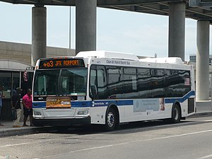
A Q3 bus stopped within John F. Kennedy Airport.
|
|||
| Overview | |||
| System | MTA Regional Bus Operations | ||
| Operator | New York City Transit Authority | ||
| Garage | Jamaica Depot | ||
| Vehicle |
|
||
| Began service | 1919 | ||
| Route | |||
| Locale | Queens | ||
| Communities served | Jamaica, Hollis, St. Albans, Springfield Gardens | ||
| Start | Jamaica, Queens – 165th Street Bus Terminal Bay 1 | ||
| Via | Hillside Avenue, Farmers Boulevard | ||
| End | JFK International Airport – Terminal 5 | ||
| Length | |||
| Service | |||
| Operates | 24 hours | ||
| Daily ridership | 3,101,830 (2015) | ||
| Fare | $2.75 (MetroCard or coins) | ||
| Cash | Coins only (exact change required) | ||
| Transfers | Yes | ||
| Timetable | Q3 | ||
|
|||
The Q3 bus route constitutes a public transit line in Queens, New York City, United States,
The Q3 starts from Bay 1 at the 165th Street Bus Terminal in Jamaica, Queens. It then goes via Hillside Avenue, until it turns south onto Farmers Boulevard via either 187th Place or 188th Street based on the direction of travel. The route continues through the neighborhoods of Hollis, stopping at the Long Island Rail Road (LIRR) station there. It then passes through St. Albans, before stopping at the LIRR station at Locust Manor. Then it continues, passing through Springfield Gardens before finally crossing Rockaway Boulevard, and then entering John F. Kennedy International Airport via North Boundary Road, passing by the North Cargo Area and Central Terminal Area before terminating at Terminal 5, where a connection to the AirTrain JFK is available.
A majority of the ridership of the Q3 is formed from airport employees from JFK. Upon the route's extension to JFK Airport, more riders began to use the Q3, there were increased employment opportunities in Queens, airport hires were encouraged to move to Queens, and road congestion was relieved.
The bus was originally operated by the Saint Albans Improvement Association by permit. The route was put under the supervision of the New York City Department of Plant & Structures in 1921 and it was established as Route 76, Saint Albans–Hollis–Jamaica on March 27, 1922. The route ran from Saint Marks Avenue, now 119th Avenue, via Farmers Avenue, Seminole Avenue and Villard Avenue, which are both now 190th Street, and Hillside Avenue to Union Hall Street.
...
Wikipedia
