Pura, Tarlac
| Pura | ||
|---|---|---|
| Municipality | ||

Pura Municipal Building
|
||
|
||
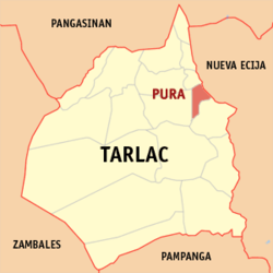
 Map of Tarlac showing the location of Pura |
||
| Location within the Philippines | ||
| Coordinates: 15°37′30″N 120°39′00″E / 15.625°N 120.65°ECoordinates: 15°37′30″N 120°39′00″E / 15.625°N 120.65°E | ||
| Country | Philippines | |
| Region | Central Luzon (Region III) | |
| Province | Tarlac | |
| District | 1st District | |
| Barangays | 16 | |
| Government | ||
| • Mayor | Concepcion A. Zarate | |
| • Vice Mayor | Manuel I. Pascua | |
| Area | ||
| • Total | 31.01 km2 (11.97 sq mi) | |
| Population (2015 census) | ||
| • Total | 23,712 | |
| • Density | 760/km2 (2,000/sq mi) | |
| Time zone | PST (UTC+8) | |
| ZIP code | 2312 | |
| IDD : area code | +63 (0)45 | |
| Income class | 4th class | |
| Website | www |
|
Pura is a fourth class municipality in the province of Tarlac, Philippines. According to the 2015 census, it has a population of 23,712 people.
Pura is located 78 kilometres (48 mi) from the regional center San Fernando, Pampanga, 55 kilometres (34 mi) from Clark Special Economic Zone (CSEZ) (Angeles City, Pampanga), 19 kilometres (12 mi) from the provincial capital Tarlac City, and 145 kilometres (90 mi) north of Manila.
Pura's topography is characterized by plain slopes, with Luisita fine sand loam and Pura clay loam soil. It is traversed by the Susubaen Creek and Baldo Creek.
It has an average monthly rainfall of 29.5 centimetres (11.6 in), an average temperature range of 24.2 to 31.4 °C (75.6 to 88.5 °F), and a wind speed of 7.1 knots/hour.
Pura is politically subdivided into 16 barangays.
In the 2015 census, the population of Pura, Tarlac, was 23,712 people, with a density of 760 inhabitants per square kilometre or 2,000 inhabitants per square mile.
Municipality of Pura is consist of 3 public secondary schools, 1 private secondary school and 9 public elementary schools namely:
...
Wikipedia


