Puerto Natales, Chile
| Puerto Natales | |||||
|---|---|---|---|---|---|
| City | |||||
 |
|||||
|
|||||
| Nickname(s): Natales | |||||
| Coordinates (city): 51°44′S 72°31′W / 51.733°S 72.517°WCoordinates: 51°44′S 72°31′W / 51.733°S 72.517°W | |||||
| Country |
|
||||
| Region |
|
||||
| Province | Última Esperanza | ||||
| Commune | Natales | ||||
| Founded | 1911 | ||||
| Government | |||||
| • Type | Municipality | ||||
| • Alcalde | Fernando Paredes Mansilla (UDI) | ||||
| Area | |||||
| • Total | 48,974.2 km2 (18,909.0 sq mi) | ||||
| Elevation | 3 m (10 ft) | ||||
| Population (2012 Census) | |||||
| • Total | 18,505 | ||||
| • Density | 0.38/km2 (0.98/sq mi) | ||||
| • Rural | 2,138 | ||||
| Sex | |||||
| • Men | 10,068 | ||||
| • Women | 9,048 | ||||
| Time zone | CLST (UTC−3) | ||||
| Area code(s) | 56 + 61 | ||||
| Website | www.muninatales.cl | ||||
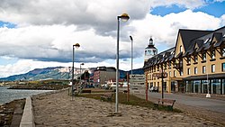
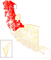
Puerto Natales is a city in Chilean Patagonia. It is the capital of both the commune of Natales and the province of Última Esperanza, one of the four provinces that make up the Magallanes and Antartica Chilena Region in the southernmost part of Chile. Puerto Natales is the only city in the province. It is located 247 km (153 mi) northwest of Punta Arenas. It is the final passenger port of call for the Navimag ferry sailing from Puerto Montt into the Señoret Channel as well as the primary transit point for travellers to Torres del Paine National Park, Chile.
It is located at the opening of Última Esperanza Sound and was originally inhabited by the Kawésqar or Alacaluf people and the Aoniken or Tehuelche people. The first European to discover the area where the city is located was Juan Ladrillero, a Spanish explorer who was looking for the Strait of Magellan's western passage in 1557.
The city was later settled by European immigrants, primarily Germans, British, including English, Welsh and Scots, Croats, Greeks, Italians and Spaniards. It was then settled by Chilean people, with a substantial number coming from the island of Chiloé, all attracted by the sheep breeding industry.
...
Wikipedia


