Puerto Galera
| Puerto Galera | |
|---|---|
| Municipality | |

Sabang Bay
|
|
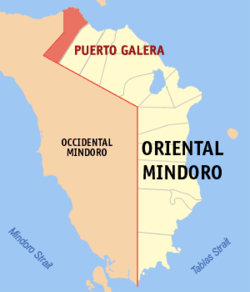
 Map of Oriental Mindoro showing the location of Puerto Galera |
|
| Location within the Philippines | |
| Coordinates: 13°30′N 120°57′E / 13.500°N 120.950°ECoordinates: 13°30′N 120°57′E / 13.500°N 120.950°E | |
| Country | Philippines |
| Region | Mimaropa (Region IV-B) |
| Province | Oriental Mindoro |
| District | 1st District of Oriental Mindoro |
| Founded | December 8, 1972 |
| Barangays | 13 |
| Government | |
| • Mayor | Rockey D. Ilagan |
| Area | |
| • Total | 247.85 km2 (95.70 sq mi) |
| Population (2010) | |
| • Total | 32,521 |
| • Density | 130/km2 (340/sq mi) |
| Time zone | PST (UTC+8) |
| ZIP code | 5203 |
| IDD : area code | +63 (0)43 |
| Income class | 1st Class; Partially Urban |
| Website | www |
Puerto Galera is the north-westernmost municipality in the province of Oriental Mindoro, Philippines. It is located at the south-western end of the Isla Verde Passage, about 130 kilometers (81 mi) south of Manila. It is mainly accessible from the Southern Luzon port of Batangas, which is acting as a gateway to the city.
Puerto Galera is politically subdivided into 13 barangays:
The National Statistical Coordination Board of the Philippines characterizes the municipality of Puerto Galera as First Class based on household income. The municipality had a population of 32,521 in the 2010 Census of Population conducted by the National Statistics Office. The population in 2012 was estimated 35,188.
Chinese traders traders possibly knew the place before the arrival of the Spaniards but there is no evidence of Chinese settlement. The place was likely also known by other Southeast Asian merchants, who found it convenient to load and unload trading goods. The State of Ma-i extended to the Puerto Galera area. The bay was a convenient place to shelter ships against bad weather and a warehouse was built to store supplies and trade black rice from Muelle.
In April 1570, the Spaniards arrived in Bombon (now known as Batangas), and later sailed through the Isla Verde passage, landed and called the place Puerto Galera (the port of Galleons). Legazpi, became the first Spanish governor-general of the island. A garrison for soldiers was built in Muelle and watch towers were erected in Dampalitan Point to monitor naval activity in the bay. Spaniards came to conquer for their king and chased the Muslim Moro pirates who were disrupting their trade with the Chinese and the natives. The later proved to be not only skilled warriors but also good negotiators even in the face of defeat.
In 1663, a change in the form of administration occurred in the island, the corregidor was replaced by the alcalde-mayor or provincial governor and the capital was moved from Puerto Galera to Baco. In the seventeenth century, the relative prosperity of the city underwent a serious setback with the rise of Muslim piracy. Both pirates attacks and the mismanagement of the Spaniards resulted in driving the native population either into exile in safer places or sending them inland to comparative safety.
...
Wikipedia

