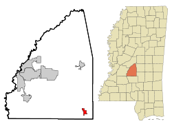
Puckett, Mississippi
| Puckett, Mississippi | |
|---|---|
| town | |
 Location of Puckett, Mississippi |
|
| Location in the United States | |
| Coordinates: 32°4′59″N 89°46′40″W / 32.08306°N 89.77778°WCoordinates: 32°4′59″N 89°46′40″W / 32.08306°N 89.77778°W | |
| Country | United States |
| State | Mississippi |
| County | Rankin |
| Government | |
| • Type | mayor, aldermen |
| • mayor | Russ Espiritu |
| Area | |
| • Total | 2.0 sq mi (5.2 km2) |
| • Land | 2.0 sq mi (5.2 km2) |
| • Water | 0.0 sq mi (0.0 km2) |
| Elevation | 341 ft (104 m) |
| Population (2000) | |
| • Total | 354 |
| • Density | 175.6/sq mi (67.8/km2) |
| Time zone | Central (CST) (UTC-6) |
| • Summer (DST) | CDT (UTC-5) |
| ZIP code | 39151 |
| Area code(s) | 601 |
| FIPS code | 28-60360 |
| GNIS feature ID | 0676410 |
| Website | http://www.puckettms.org |
Puckett is a village in Rankin County, Mississippi. The population was 354 at the 2000 census. It is part of the Jackson Metropolitan Statistical Area.
The first European-American settlement at this location was in 1837, and the pioneers named it Clear Creek. One of the first settlers was Calvin Boone. A man known by the surname Merchant is credited with building the first water mill in the area, and with blazing a road along a ridge leading to another settlement then known as Shiloh. Settlers migrated from Alabama. A.A. Burnham applied for a US post office in 1890, asking that it be named either Clear Creek or Burnham. Due to these names already being used, the USPS assigned the name of Puckett to the post office, after the Puckett family, who came from nearby Tishomingo.. Early in the town's history, a traveling show wintered there for a number of years. Attendance at its winter performances led to the town's being nicknamed "the largest little show place in the world". In the 1950s a sign was erected, saying "Welcome to Puckett 300 good friendly folks and a few old sore heads".
Puckett is located at 32°4′59″N 89°46′40″W / 32.08306°N 89.77778°W (32.083100, -89.777658).
According to the United States Census Bureau, the village has a total area of 2.0 square miles (5.2 km2), of which 2.0 square miles (5.2 km2) is land and 0.50% is water.
As of the census of 2000, there were 354 people, 136 households, and 110 families residing in the village. The population density was 175.6 people per square mile (67.7/km²). There were 151 housing units at an average density of 74.9 per square mile (28.9/km²). The racial makeup of the village was 96.33% White, 2.82% African American, and 0.85% from two or more races.
...
Wikipedia

