Proserpine, Queensland
|
Proserpine Queensland |
|||||||
|---|---|---|---|---|---|---|---|

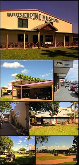
Top: Proserpine Museum, Upper left: Proserpine Entertainment Centre, Upper right: Main St, Lower left: Whitsunday Regional Council Offices, Lower right: Proserpine Library, Bottom left: Ken MacPherson Memorial Gardens, Bottom right: Pioneer Park
|
|||||||
| Coordinates | 20°24′6″S 148°34′53″E / 20.40167°S 148.58139°ECoordinates: 20°24′6″S 148°34′53″E / 20.40167°S 148.58139°E | ||||||
| Population | 3,390 (2011 census) | ||||||
| Established | 1890s | ||||||
| Postcode(s) | 4800 | ||||||
| Elevation | 20 m (66 ft) | ||||||
| Time zone | AEST (UTC+10) | ||||||
| Location | |||||||
| LGA(s) | Whitsunday Regional Council | ||||||
| State electorate(s) | Whitsunday | ||||||
| Federal Division(s) | Dawson | ||||||
|
|||||||
Proserpine (/ˈprɒsərpaɪn/, locally [ˈpɹɔsəpɑen]) is a town in Whitsunday Region in the state of Queensland, Australia. It is situated on the Bruce Highway. It was founded in the 1890s. In the 2011 census, Proserpine had a population of 3,390. Proserpine is an anchor for the Whitsundays region, providing some key infrastructure, including the rail station, the mainland airport for scheduled jet services, two high schools, the hospital and other vital services. It is a future base for workers involved in nearby mines including the $22 billion Adani Carmichael coal project.
The town is located along the banks of the Proserpine River and is surrounded by vast flat areas of land primarily used for cane farming. It prides itself on its friendly atmosphere and in 2007 it won the Tourism Queensland Friendliest town award. Proserpine is experiencing a resurgence in economic growth fueled by its Airport gaining International services in 2017, its affordability and its short commute distance to the mines.
The town name Proserpine derives from the Proserpine River, whose name was derived from the legend of the Greek goddess Persephone (whose Latin name is Proserpine).
The town was founded around 1890 just after the sugar mill was constructed. The Postal Office opened in 1886. The town experienced high growth in the 1900s as the local sugar industry grew and exported raw sugar via the Proserpine Landing from here it was sent to refineries. At this time it was the fastest growing regional town in Queensland.
In the 1950s the Proserpine Airport was opened which increased the towns accessibility by air. In 1986 construction commenced on the Peter Faust Dam 25 kilometres (16 mi) NW of the town to be used for flood mitigation during the wet season and irrigation during the dry, the dam was completed in 1990 and was expected to take decades to fill but a passing cyclone helped boost levels close to maximum capacity. The 1990s saw the Proserpine Sugar Mill crush a record amount of cane in 1996.
...
Wikipedia

