Poso
| Poso | |
|---|---|
| Town | |
 |
|
| Coordinates: 1°24′S 120°45′E / 1.400°S 120.750°ECoordinates: 1°24′S 120°45′E / 1.400°S 120.750°E | |
| Country |
|
| Province | Central Sulawesi |
| Regency | Poso |
| Population (2010 Census) | |
| • Total | 40,300 |
| Time zone | +8 (UTC+8) |
| Website | http://posokab.go.id/ |
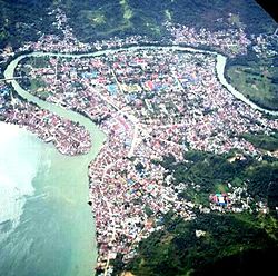
Poso is the main port and transportation hub for the north-eastern coast of Central Sulawesi, Indonesia. Its geographical location is 1°24′S 120°45′E / 1.400°S 120.750°E.
Poso is the administrative capital of Poso Regency (one of ten regencies in Central Sulawesi Province), is located exactly in the middle of the province on the shore of the Gulf of Tomini, right in the central part of Sulawesi island, and is the main port and transportation hub for the north-eastern coast of Sulawesi. It is not to be confused with Lake Poso, which is some distance inland. With the total of population of over 40,000, Poso is one of the biggest and the oldest towns in the province.
The central location of Poso has made it a stopover either from the north to the south, or from west to the east of Sulawesi. It is for this reason that the population of Poso consists of many different ethnicities, religions and backgrounds. People living in Poso are spread from the coastal area to the mountainous region, with the main sources of income being farming and fishing.
Poso can be reached by plane from Palu or by bus from many other big cities on Sulawesi, and is situated on the equator. It features tropical rain forest, seashore gardens and other natural scenery. Sintuwu Maroso Square is the main town square and located in central Poso. Rumah Katu Marine Park is the water park located 10 km from the center of Poso.
...
Wikipedia

