Portswood
| Portswood | |
|---|---|
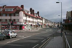
 Portswood's shopping area (Portswood Road) |
|
| Portswood shown within Southampton | |
| Area | 2.79 km2 (1.08 sq mi) |
| Population | 14,831 |
| • Density | 5,316/km2 (13,770/sq mi) |
| OS grid reference | SU434150 |
| Unitary authority | |
| Ceremonial county | |
| Region | |
| Country | England |
| Sovereign state | United Kingdom |
| Post town | SOUTHAMPTON |
| Postcode district | SO17 |
| Dialling code | 023 |
| Police | Hampshire |
| Fire | Hampshire |
| Ambulance | South Central |
| EU Parliament | South East England |
| UK Parliament | |
Portswood is a suburb and Electoral Ward of Southampton, England. The suburb lies to the north-north-east of the city centre and is bounded by (clockwise from west) Freemantle, Highfield, Swaythling, St. Denys and Bevois Valley.
Portswood Ward comprises Portswood, Highfield and St. Denys, and had a population of 14,831 at the 2011 Census. It is a largely residential area adjacent to the main campus of the University of Southampton, and as such more than a quarter of residents are students.
The Manor of Portswood, which originally included the modern-day Bevois Town, Swaythling, St Denys and Highfield, was first named in a charter dating from 1045. The name Portswood comes from the Old English Porteswuda, meaning "wood of the town".
The manor was granted to St. Denys Priory by Richard I in 1189, and it remained under their ownership until the Dissolution of the Monasteries by Henry VIII in 1536. The land, and the title Lord of the Manor, were purchased by Francis Dawtrey in 1538, and passed through several hands before being bought by Giles Stibbert in 1771. Stibbert, Lieutenant-General with the East India Company and later Commander-in-Chief of India, built the first Portswood House on the estate to the design of a Mr. Crunden.
...
Wikipedia

